Ndioum geodata
Ndioum (Saint-Louis) is a populated place; located in Senegal in Africa/Dakar (GMT+0) time zone. With population of 13,198 people, there are 34 cities with bigger population in this country. Compared to other cities in Senegal, 100% of cities are located further ↓South; 80% of cities are located further ←West and 53.3% of cities have higher elevation than Ndioum. Note1


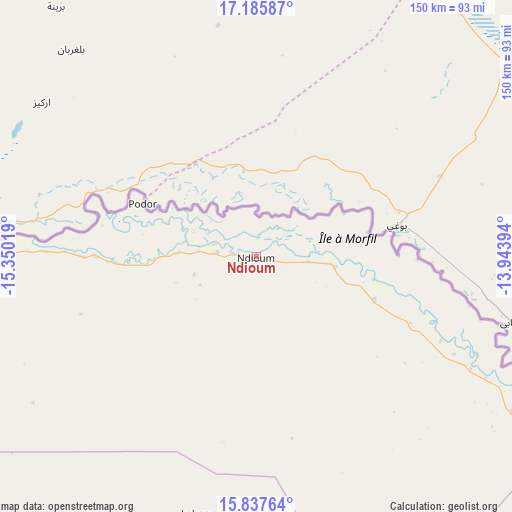
Ndioum GPS coordinates[2]
16° 30' 46.548" North, 14° 38' 49.416" West
| Map corner | latitude | longitude |
|---|---|---|
| Upper-left | 17.18587°, | -15.35019° |
| Center: | 16.51293°, | -14.64706° |
| Lower-right: | 15.83764°, | -13.94394° |
| Map W x H: | 149.9×149.9 km | = 93.1×93.1mi |
| max Lat: | 16.51293° ⇑0% North |
| Ndioum: | 16.51293° |
| min Lat: | ⇓100% South 12.485° |
| min Long | Ndioum | max Long |
| -17.47581° | -14.64706° | -12.18076° |
| W 80%⇐ | ⇒20% E |
Elevation
Elevation of Ndioum is 18 m = 59 ft, and this is 6.5 m = 21 ft below average elevation for this country.
| Max E: |
127 m = 417 ft | 53.3% |
| Avg. | 24.5 m = 80 ft | |
| Ndioum | 18 m = 59 ft | |
Min E: |
0 m = 0 ft | 46.7% |
See also: Senegal elevation on elevation.city.
Geographical zone
Ndioum is located in North Torrid zone (between Equator and Tropic of Cancer). Distance of this Northern Tropic circle is 769.9 km =478.4 mi to North.| Distance of | km | miles | from Ndioum |
|---|---|---|---|
| North Pole | 8171 | 5077.2 | to North |
| Arctic Circle | 5565.1 | 3458 | to North |
| Tropic Cancer | 769.9 | 478.4 | to North |
| Equator | 1836.1 | 1140.9 | to South |


Nearby cities:
15 places around Ndioum: (largest is in red/bold)
• Dara
157.1 km =97.6 mi,  214°
214°
• Goléré
64.8 km =40.3 mi,  116°
116°
• Guéoul
215 km =133.6 mi,  237°
237°
• Kanel
193.9 km =120.5 mi,  125°
125°
• Louga
195.7 km =121.6 mi, 239°
• Matam
176.6 km =109.7 mi, 122°
• Ndibène Dahra
158.3 km =98.4 mi, 214°
• Ouro Sogui
173.8 km =108 mi, 125°
• Polel Diaoubé
224.1 km =139.2 mi, 128°
• Ranérou
153.2 km =95.2 mi,  151°
151°
• Richard-Toll
112.5 km =69.9 mi,  267°
267°
• Rosso
123.2 km =76.6 mi, 265°
• Saint-Louis
204.2 km =126.9 mi,  254°
254°
• Sémé
233.8 km =145.3 mi, 128°
• Touba
227.4 km =141.3 mi,  215°
215°
Sources, notices
• [Note1] Compared only with cities in Senegal existing in our database
• [Src1] Map data: © OpenStreetMap contributors (CC-BY-SA)
• [Src2] Other city data from geonames.org with taken over terms of usage.
• [Src3] Geographical zone / Annual Mean Temperature by Robert A. Rohde @ Wikipedia
