N'Djamena geodata
N'Djamena (Chari-Baguirmi) is a capital of a political entity; located in Chad in Africa/Ndjamena (GMT+1) time zone. With population of 721,081 people, there are 0 cities with bigger population in this country. Compared to other cities in Chad, 55.3% of cities are located further ↓South; 91.5% of cities are located further →East and 87.2% of cities have higher elevation than N'Djamena. Note1


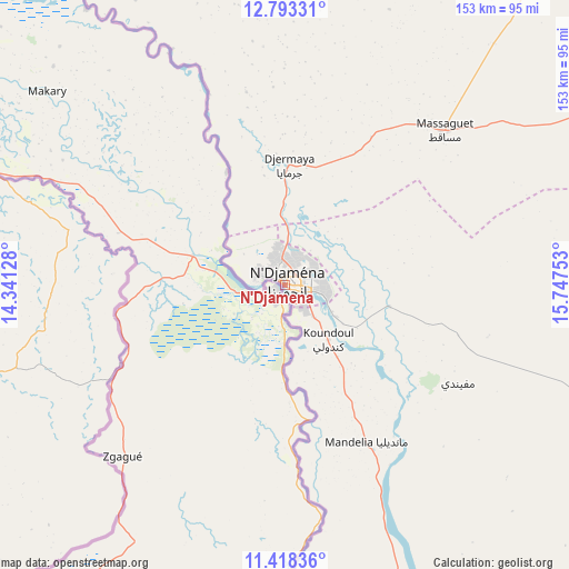
N'Djamena GPS coordinates[2]
12° 6' 24.192" North, 15° 2' 39.84" East
| Map corner | latitude | longitude |
|---|---|---|
| Upper-left | 12.79331°, | 14.34128° |
| Center: | 12.10672°, | 15.0444° |
| Lower-right: | 11.41836°, | 15.74753° |
| Map W x H: | 152.9×152.9 km | = 95×95mi |
| max Lat: | 21.8375° ⇑44.7% North |
| N'Djamena: | 12.10672° |
| min Lat: | ⇓55.3% South 8.26681° |
| min Long | N'Djamena | max Long |
| 14.1539° | 15.0444° | 22.84308° |
| W 8.5%⇐ | ⇒91.5% E |
Elevation
Elevation of N'Djamena is 299 m = 981 ft, and this is 138.3 m = 454 ft below average elevation for this country.
| Max E: |
1046 m = 3432 ft | 87.2% |
| Avg. | 437.3 m = 1435 ft | |
| N'Djamena | 299 m = 981 ft | |
Min E: |
242 m = 794 ft | 12.8% |
See also: N'Djamena elevation on elevation.city.
Geographical zone
N'Djamena is located in North Torrid zone (between Equator and Tropic of Cancer). Distance of this Northern Tropic circle is 1259.8 km =782.8 mi to North.| Distance of | km | miles | from N'Djamena |
|---|---|---|---|
| North Pole | 8660.9 | 5381.6 | to North |
| Arctic Circle | 6055 | 3762.4 | to North |
| Tropic Cancer | 1259.8 | 782.8 | to North |
| Equator | 1346.1 | 836.4 | to South |


Nearby cities:
15 places around N'Djamena: (largest is in red/bold)
• Bokoro
221 km =137.3 mi,  82°
82°
• Bol
155.4 km =96.6 mi,  346°
346°
• Bongor
206.2 km =128.1 mi,  170°
170°
• Bousso
256 km =159.1 mi,  134°
134°
• Dourbali
95.5 km =59.3 mi,  110°
110°
• Gounou Gaya
280.2 km =174.1 mi, 169°
• Guelendeng
143.2 km =89 mi,  157°
157°
• Mao
225.8 km =140.3 mi,  7°
7°
• Massaguet
59.1 km =36.7 mi,  46°
46°
• Massakory
123.7 km =76.9 mi,  36°
36°
• Massenya
145.4 km =90.3 mi,  122°
122°
• Mboursou Léré
278 km =172.7 mi,  200°
200°
• Moussoro
231.6 km =143.9 mi, 42°
• Ngama
233.6 km =145.2 mi,  98°
98°
• Vadanakallu
248.7 km =154.5 mi,  337°
337°
In other languages:
- In Spanish: Yamena
- In France: Ndjamena
- In German: N’Djamena, Indschamina
- In Russian: Нджамена
Sources, notices
• [Note1] Compared only with cities in Chad existing in our database
• [Src1] Map data: © OpenStreetMap contributors (CC-BY-SA)
• [Src2] Other city data from geonames.org with taken over terms of usage.
• [Src3] Geographical zone / Annual Mean Temperature by Robert A. Rohde @ Wikipedia
