Bol geodata
Bol (Lac) is a seat of a first-order administrative division; located in Chad in Africa/Ndjamena (GMT+1) time zone. With population of 11,700 people, there are 31 cities with bigger population in this country. Compared to other cities in Chad, 74.5% of cities are located further ↓South; 95.7% of cities are located further →East and 91.5% of cities have higher elevation than Bol. Note1


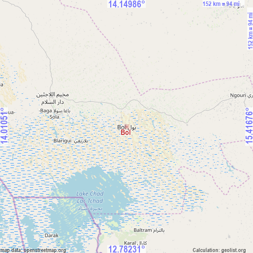
Bol GPS coordinates[2]
13° 28' 1.416" North, 14° 42' 49.068" East
| Map corner | latitude | longitude |
|---|---|---|
| Upper-left | 14.14986°, | 14.01051° |
| Center: | 13.46706°, | 14.71363° |
| Lower-right: | 12.78231°, | 15.41676° |
| Map W x H: | 152.1×152.1 km | = 94.5×94.5mi |
| max Lat: | 21.8375° ⇑25.5% North |
| Bol: | 13.46706° |
| min Lat: | ⇓74.5% South 8.26681° |
| min Long | Bol | max Long |
| 14.1539° | 14.71363° | 22.84308° |
| W 4.3%⇐ | ⇒95.7% E |
Elevation
Elevation of Bol is 293 m = 961 ft, and this is 144.3 m = 473 ft below average elevation for this country.
| Max E: |
1046 m = 3432 ft | 91.5% |
| Avg. | 437.3 m = 1435 ft | |
| Bol | 293 m = 961 ft | |
Min E: |
242 m = 794 ft | 8.5% |
See also: Chad elevation on elevation.city.
Geographical zone
Bol is located in North Torrid zone (between Equator and Tropic of Cancer). Distance of this Northern Tropic circle is 1108.5 km =688.8 mi to North.| Distance of | km | miles | from Bol |
|---|---|---|---|
| North Pole | 8509.7 | 5287.7 | to North |
| Arctic Circle | 5903.8 | 3668.5 | to North |
| Tropic Cancer | 1108.5 | 688.8 | to North |
| Equator | 1497.4 | 930.4 | to South |


Nearby cities:
15 places around Bol: (largest is in red/bold)
• Ati
392.8 km =244.1 mi,  94°
94°
• Bitkine
414.1 km =257.3 mi,  113°
113°
• Bokoro
281.5 km =174.9 mi,  115°
115°
• Bongor
361.5 km =224.6 mi,  168°
168°
• Bousso
396.4 km =246.3 mi,  146°
146°
• Dourbali
223.1 km =138.6 mi, 145°
• Guelendeng
297.7 km =185 mi,  162°
162°
• Mao
97.2 km =60.4 mi,  41°
41°
• Massaguet
135.2 km =84 mi,  144°
144°
• Massakory
121.8 km =75.7 mi, 115°
• Massenya
278.6 km =173.1 mi, 145°
• Moussoro
192.9 km =119.9 mi,  84°
84°
• N'Djamena
155.4 km =96.6 mi, 166°
• Ngama
325.4 km =202.2 mi,  125°
125°
• Vadanakallu
98 km =60.9 mi,  323°
323°
Sources, notices
• [Note1] Compared only with cities in Chad existing in our database
• [Src1] Map data: © OpenStreetMap contributors (CC-BY-SA)
• [Src2] Other city data from geonames.org with taken over terms of usage.
• [Src3] Geographical zone / Annual Mean Temperature by Robert A. Rohde @ Wikipedia
