Neftobod geodata
Neftobod (Sughd) is a populated place; located in Tajikistan in Asia/Dushanbe (GMT+5) time zone. With population of 4,603 people, there are 50 cities with bigger population in this country. Compared to other cities in Tajikistan, 85.2% of cities are located further ↓South; 86.4% of cities are located further ←West and 54.5% of cities have higher elevation than Neftobod. Note1


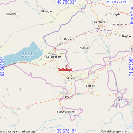
Neftobod GPS coordinates[2]
40° 12' 54.864" North, 70° 34' 18.948" East
| Map corner | latitude | longitude |
|---|---|---|
| Upper-left | 40.75003°, | 69.86881° |
| Center: | 40.21524°, | 70.57193° |
| Lower-right: | 39.67619°, | 71.27506° |
| Map W x H: | 119.4×119.4 km | = 74.2×74.2mi |
| max Lat: | 40.99827° ⇑14.8% North |
| Neftobod: | 40.21524° |
| min Lat: | ⇓85.2% South 36.72484° |
| min Long | Neftobod | max Long |
| 67.60931° | 70.57193° | 73.96674° |
| W 86.4%⇐ | ⇒13.6% E |
Elevation
Elevation of Neftobod is 687 m = 2254 ft, and this is 275.5 m = 904 ft below average elevation for this country.
| Max E: |
3607 m = 11834 ft | 54.5% |
| Avg. | 962.5 m = 3158 ft | |
| Neftobod | 687 m = 2254 ft | |
Min E: |
324 m = 1063 ft | 45.5% |
See also: Tajikistan elevation on elevation.city.
Geographical zone
Neftobod is located in North temperate zone (between Tropic of Cancer and the Arctic Circle). Distance of this Northern Tropic circle is 1865.6 km =1159.2 mi to South.| Distance of | km | miles | from Neftobod |
|---|---|---|---|
| North Pole | 5535.5 | 3439.6 | to North |
| Arctic Circle | 2929.7 | 1820.4 | to North |
| Tropic Cancer | 1865.6 | 1159.2 | to South |
| Equator | 4471.5 | 2778.5 | to South |


Nearby cities:
15 places around Neftobod: (largest is in red/bold)
• Adrasmon
69.3 km =43.1 mi,  314°
314°
• Chkalov
74.5 km =46.3 mi,  271°
271°
• Ghafurov
71.6 km =44.5 mi, 270°
• Isfara
10.9 km =6.8 mi,  155°
155°
• Khŭjand
80.9 km =50.3 mi,  275°
275°
• Kim
8.8 km =5.5 mi,  264°
264°
• Konibodom
14.8 km =9.2 mi, 306°
• Konsoy
79.8 km =49.6 mi,  292°
292°
• Navgarzan
87.9 km =54.6 mi,  352°
352°
• Palos
71.7 km =44.6 mi, 279°
• Proletar
91.1 km =56.6 mi, 266°
• Shaydon
53.9 km =33.5 mi,  339°
339°
• Shŭrob
19 km =11.8 mi,  187°
187°
• Taboshar
88.1 km =54.7 mi,  296°
296°
• Vorukh
40.5 km =25.2 mi,  179°
179°
Sources, notices
• [Note1] Compared only with cities in Tajikistan existing in our database
• [Src1] Map data: © OpenStreetMap contributors (CC-BY-SA)
• [Src2] Other city data from geonames.org with taken over terms of usage.
• [Src3] Geographical zone / Annual Mean Temperature by Robert A. Rohde @ Wikipedia
