Isfara geodata
Isfara (Sughd) is a seat of a second-order administrative division; located in Tajikistan in Asia/Dushanbe (GMT+5) time zone. With population of 37,738 people, there are 7 cities with bigger population in this country. Compared to other cities in Tajikistan, 78.4% of cities are located further ↓South; 88.6% of cities are located further ←West and 52.3% of cities have lower elevation than Isfara. Note1


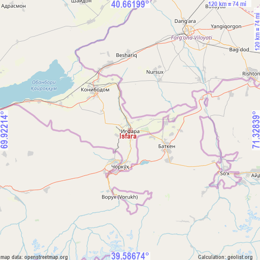
Isfara GPS coordinates[2]
40° 7' 35.364" North, 70° 37' 30.936" East
| Map corner | latitude | longitude |
|---|---|---|
| Upper-left | 40.66199°, | 69.92214° |
| Center: | 40.12649°, | 70.62526° |
| Lower-right: | 39.58674°, | 71.32839° |
| Map W x H: | 119.6×119.6 km | = 74.3×74.3mi |
| max Lat: | 40.99827° ⇑21.6% North |
| Isfara: | 40.12649° |
| min Lat: | ⇓78.4% South 36.72484° |
| min Long | Isfara | max Long |
| 67.60931° | 70.62526° | 73.96674° |
| W 88.6%⇐ | ⇒11.4% E |
Elevation
Elevation of Isfara is 824 m = 2703 ft, and this is 138.5 m = 454 ft below average elevation for this country.
| Max E: |
3607 m = 11834 ft | 47.7% |
| Avg. | 962.5 m = 3158 ft | |
| Isfara | 824 m = 2703 ft | |
Min E: |
324 m = 1063 ft | 52.3% |
See also: Tajikistan elevation on elevation.city.
Geographical zone
Isfara is located in North temperate zone (between Tropic of Cancer and the Arctic Circle). Distance of this Northern Tropic circle is 1855.7 km =1153.1 mi to South.| Distance of | km | miles | from Isfara |
|---|---|---|---|
| North Pole | 5545.4 | 3445.8 | to North |
| Arctic Circle | 2939.5 | 1826.5 | to North |
| Tropic Cancer | 1855.7 | 1153.1 | to South |
| Equator | 4461.6 | 2772.3 | to South |


Nearby cities:
15 places around Isfara: (largest is in red/bold)
• Adrasmon
79.5 km =49.4 mi,  316°
316°
• Chkalov
79.9 km =49.6 mi,  278°
278°
• Ghafurov
76.8 km =47.7 mi, 277°
• Khŭjand
86.9 km =54 mi, 281°
• Kim
16.1 km =10 mi,  304°
304°
• Konibodom
24.9 km =15.5 mi, 318°
• Konsoy
88.1 km =54.7 mi, 297°
• Navgarzan
98.4 km =61.1 mi,  350°
350°
• Neftobod
10.9 km =6.8 mi,  335°
335°
• Palos
78.3 km =48.7 mi,  285°
285°
• Proletar
95.6 km =59.4 mi,  272°
272°
• Shaydon
64.8 km =40.3 mi, 338°
• Shŭrob
11.5 km =7.1 mi,  218°
218°
• Taboshar
96.8 km =60.1 mi, 300°
• Vorukh
30.8 km =19.1 mi,  187°
187°
Sources, notices
• [Note1] Compared only with cities in Tajikistan existing in our database
• [Src1] Map data: © OpenStreetMap contributors (CC-BY-SA)
• [Src2] Other city data from geonames.org with taken over terms of usage.
• [Src3] Geographical zone / Annual Mean Temperature by Robert A. Rohde @ Wikipedia
