Kalabo geodata
Kalabo (Western) is a populated place; located in Zambia in Africa/Lusaka (GMT+2) time zone. With population of 7,731 people, there are 45 cities with bigger population in this country. Compared to other cities in Zambia, 72.7% of cities are located further ↑North; 100% of cities are located further →East and 71.2% of cities have higher elevation than Kalabo. Note1


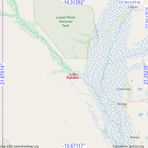
Kalabo GPS coordinates[2]
14° 59' 35.052" South, 22° 40' 45.336" East
| Map corner | latitude | longitude |
|---|---|---|
| Upper-left | -14.31282°, | 21.97614° |
| Center: | -14.99307°, | 22.67926° |
| Lower-right: | -15.67117°, | 23.38239° |
| Map W x H: | 151×151 km | = 93.8×93.8mi |
| max Lat: | -8.46887° ⇑72.7% North |
| Kalabo: | -14.99307° |
| min Lat: | ⇓27.3% South -17.84194° |
| min Long | Kalabo | max Long |
| 22.67926° | 22.67926° | 33.1782° |
| W 0%⇐ | ⇒100% E |
Elevation
Elevation of Kalabo is 1029 m = 3376 ft, and this is 114.4 m = 375 ft below average elevation for this country.
| Max E: |
1622 m = 5322 ft | 71.2% |
| Avg. | 1143.4 m = 3751 ft | |
| Kalabo | 1029 m = 3376 ft | |
Min E: |
328 m = 1076 ft | 28.8% |
See also: Zambia elevation on elevation.city.
Geographical zone
Kalabo is located in South Torrid zone (between Equator and Tropic of Capricorn). Distance of this Southern Tropic circle is 938.8 km =583.3 mi to South.| Distance of | km | miles | from Kalabo |
|---|---|---|---|
| Equator | 1667.1 | 1035.9 | to North |
| Tropic Capricorn | 938.8 | 583.3 | to South |
| Antarctic Circle | 5734.1 | 3563 | to South |
| South Pole | 8340 | 5182.2 | to South |


Nearby cities:
13 places around Kalabo: (largest is in red/bold)
• Kabompo
226.1 km =140.5 mi,  46°
46°
• Kalengwa
302.6 km =188 mi,  55°
55°
• Kaoma
229.1 km =142.4 mi,  84°
84°
• Kasempa
380.4 km =236.4 mi, 63°
• Limulunga
50.5 km =31.4 mi,  103°
103°
• Lukulu
91.9 km =57.1 mi,  41°
41°
• Mongu
55.9 km =34.7 mi,  120°
120°
• Mufumbwe
270.9 km =168.3 mi, 57°
• Mwinilunga
408.7 km =254 mi,  27°
27°
• Namwala
411.7 km =255.8 mi, 101°
• Senanga
139.9 km =86.9 mi,  153°
153°
• Sesheke
325.6 km =202.3 mi, 147°
• Zambezi
167.6 km =104.1 mi,  15°
15°
Sources, notices
• [Note1] Compared only with cities in Zambia existing in our database
• [Src1] Map data: © OpenStreetMap contributors (CC-BY-SA)
• [Src2] Other city data from geonames.org with taken over terms of usage.
• [Src3] Geographical zone / Annual Mean Temperature by Robert A. Rohde @ Wikipedia
