Sesheke geodata
Sesheke (Western) is a populated place; located in Zambia in Africa/Lusaka (GMT+2) time zone. With population of 20,149 people, there are 25 cities with bigger population in this country. Compared to other cities in Zambia, 98.5% of cities are located further ↑North; 89.4% of cities are located further →East and 86.4% of cities have higher elevation than Sesheke. Note1


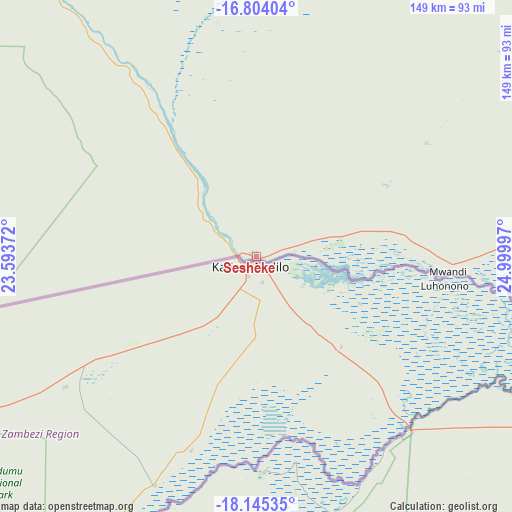
Sesheke GPS coordinates[2]
17° 28' 33.348" South, 24° 17' 48.624" East
| Map corner | latitude | longitude |
|---|---|---|
| Upper-left | -16.80404°, | 23.59372° |
| Center: | -17.47593°, | 24.29684° |
| Lower-right: | -18.14535°, | 24.99997° |
| Map W x H: | 149.1×149.1 km | = 92.6×92.6mi |
| max Lat: | -8.46887° ⇑98.5% North |
| Sesheke: | -17.47593° |
| min Lat: | ⇓1.5% South -17.84194° |
| min Long | Sesheke | max Long |
| 22.67926° | 24.29684° | 33.1782° |
| W 10.6%⇐ | ⇒89.4% E |
Elevation
Elevation of Sesheke is 951 m = 3120 ft, and this is 192.4 m = 631 ft below average elevation for this country.
| Max E: |
1622 m = 5322 ft | 86.4% |
| Avg. | 1143.4 m = 3751 ft | |
| Sesheke | 951 m = 3120 ft | |
Min E: |
328 m = 1076 ft | 13.6% |
See also: Zambia elevation on elevation.city.
Geographical zone
Sesheke is located in South Torrid zone (between Equator and Tropic of Capricorn). Distance of this Southern Tropic circle is 662.8 km =411.8 mi to South.| Distance of | km | miles | from Sesheke |
|---|---|---|---|
| Equator | 1943.1 | 1207.4 | to North |
| Tropic Capricorn | 662.8 | 411.8 | to South |
| Antarctic Circle | 5458 | 3391.4 | to South |
| South Pole | 8063.9 | 5010.7 | to South |


Nearby cities:
15 places around Sesheke: (largest is in red/bold)
• Choma
295.3 km =183.5 mi,  75°
75°
• Gwembe
368.4 km =228.9 mi,  72°
72°
• Kalabo
325.6 km =202.3 mi,  327°
327°
• Kaoma
304.2 km =189 mi,  10°
10°
• Limulunga
292 km =181.4 mi, 334°
• Livingstone
170 km =105.6 mi,  103°
103°
• Lukulu
363.2 km =225.7 mi,  341°
341°
• Maamba
302.9 km =188.2 mi,  87°
87°
• Mazabuka
409.4 km =254.4 mi,  63°
63°
• Mongu
277.3 km =172.3 mi, 333°
• Monze
364 km =226.2 mi, 68°
• Mumbwa
404.9 km =251.6 mi,  46°
46°
• Namwala
298.1 km =185.2 mi, 49°
• Senanga
186.7 km =116 mi,  324°
324°
• Sinazongwe
336.7 km =209.2 mi, 85°
Sources, notices
• [Note1] Compared only with cities in Zambia existing in our database
• [Src1] Map data: © OpenStreetMap contributors (CC-BY-SA)
• [Src2] Other city data from geonames.org with taken over terms of usage.
• [Src3] Geographical zone / Annual Mean Temperature by Robert A. Rohde @ Wikipedia
