Kabompo geodata
Kabompo (North-Western) is a populated place; located in Zambia in Africa/Lusaka (GMT+2) time zone. With population of 6,592 people, there are 50 cities with bigger population in this country. Compared to other cities in Zambia, 53% of cities are located further ↑North; 90.9% of cities are located further →East and 62.1% of cities have higher elevation than Kabompo. Note1


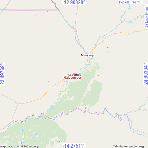
Kabompo GPS coordinates[2]
13° 35' 33.648" South, 24° 12' 2.916" East
| Map corner | latitude | longitude |
|---|---|---|
| Upper-left | -12.90828°, | 23.49769° |
| Center: | -13.59268°, | 24.20081° |
| Lower-right: | -14.27511°, | 24.90394° |
| Map W x H: | 152×152 km | = 94.4×94.4mi |
| max Lat: | -8.46887° ⇑53% North |
| Kabompo: | -13.59268° |
| min Lat: | ⇓47% South -17.84194° |
| min Long | Kabompo | max Long |
| 22.67926° | 24.20081° | 33.1782° |
| W 9.1%⇐ | ⇒90.9% E |
Elevation
Elevation of Kabompo is 1113 m = 3652 ft, and this is 30.4 m = 100 ft below average elevation for this country.
| Max E: |
1622 m = 5322 ft | 62.1% |
| Avg. | 1143.4 m = 3751 ft | |
| Kabompo | 1113 m = 3652 ft | |
Min E: |
328 m = 1076 ft | 37.9% |
See also: Zambia elevation on elevation.city.
Geographical zone
Kabompo is located in South Torrid zone (between Equator and Tropic of Capricorn). Distance of this Southern Tropic circle is 1094.6 km =680.2 mi to South.| Distance of | km | miles | from Kabompo |
|---|---|---|---|
| Equator | 1511.4 | 939.1 | to North |
| Tropic Capricorn | 1094.6 | 680.2 | to South |
| Antarctic Circle | 5889.8 | 3659.8 | to South |
| South Pole | 8495.7 | 5279 | to South |


Nearby cities:
15 places around Kabompo: (largest is in red/bold)
• Kalabo
226.1 km =140.5 mi,  226°
226°
• Kalengwa
87.8 km =54.6 mi,  80°
80°
• Kansanshi
293.2 km =182.2 mi,  55°
55°
• Kaoma
147.3 km =91.5 mi,  153°
153°
• Kasempa
177.2 km =110.1 mi,  85°
85°
• Limulunga
202.7 km =126 mi,  214°
214°
• Lukulu
134.9 km =83.8 mi, 230°
• Mongu
217.4 km =135.1 mi, 212°
• Mufumbwe
65.5 km =40.7 mi,  98°
98°
• Mumbwa
344.9 km =214.3 mi,  116°
116°
• Mwinilunga
207.9 km =129.2 mi,  6°
6°
• Namwala
339.8 km =211.1 mi,  134°
134°
• Senanga
298.1 km =185.2 mi,  199°
199°
• Solwezi
285.2 km =177.2 mi, 56°
• Zambezi
118.6 km =73.7 mi,  272°
272°
Sources, notices
• [Note1] Compared only with cities in Zambia existing in our database
• [Src1] Map data: © OpenStreetMap contributors (CC-BY-SA)
• [Src2] Other city data from geonames.org with taken over terms of usage.
• [Src3] Geographical zone / Annual Mean Temperature by Robert A. Rohde @ Wikipedia
