Lukulu geodata
Lukulu (Western) is a populated place; located in Zambia in Africa/Lusaka (GMT+2) time zone. With population of 3,349 people, there are 62 cities with bigger population in this country. Compared to other cities in Zambia, 63.6% of cities are located further ↑North; 93.9% of cities are located further →East and 69.7% of cities have higher elevation than Lukulu. Note1


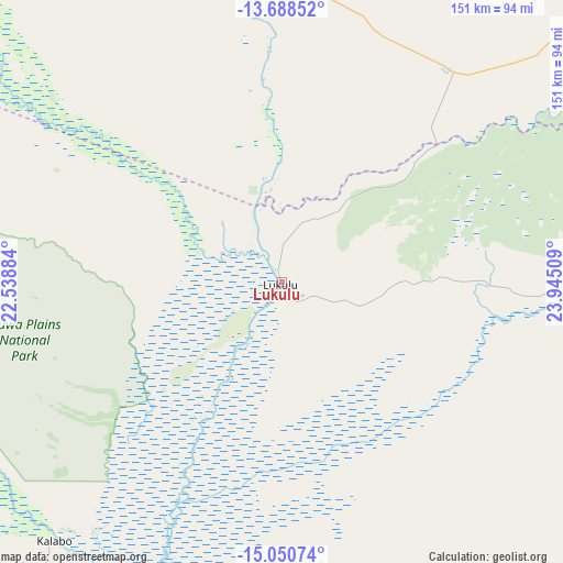
Lukulu GPS coordinates[2]
14° 22' 14.412" South, 23° 14' 31.056" East
| Map corner | latitude | longitude |
|---|---|---|
| Upper-left | -13.68852°, | 22.53884° |
| Center: | -14.37067°, | 23.24196° |
| Lower-right: | -15.05074°, | 23.94509° |
| Map W x H: | 151.5×151.5 km | = 94.1×94.1mi |
| max Lat: | -8.46887° ⇑63.6% North |
| Lukulu: | -14.37067° |
| min Lat: | ⇓36.4% South -17.84194° |
| min Long | Lukulu | max Long |
| 22.67926° | 23.24196° | 33.1782° |
| W 6.1%⇐ | ⇒93.9% E |
Elevation
Elevation of Lukulu is 1048 m = 3438 ft, and this is 95.4 m = 313 ft below average elevation for this country.
| Max E: |
1622 m = 5322 ft | 69.7% |
| Avg. | 1143.4 m = 3751 ft | |
| Lukulu | 1048 m = 3438 ft | |
Min E: |
328 m = 1076 ft | 30.3% |
See also: Zambia elevation on elevation.city.
Geographical zone
Lukulu is located in South Torrid zone (between Equator and Tropic of Capricorn). Distance of this Southern Tropic circle is 1008.1 km =626.4 mi to South.| Distance of | km | miles | from Lukulu |
|---|---|---|---|
| Equator | 1597.9 | 992.9 | to North |
| Tropic Capricorn | 1008.1 | 626.4 | to South |
| Antarctic Circle | 5803.3 | 3606 | to South |
| South Pole | 8409.2 | 5225.2 | to South |


Nearby cities:
15 places around Lukulu: (largest is in red/bold)
• Kabompo
134.9 km =83.8 mi,  50°
50°
• Kalabo
91.9 km =57.1 mi,  221°
221°
• Kalengwa
215 km =133.6 mi,  62°
62°
• Kaoma
173.8 km =108 mi,  105°
105°
• Kasempa
297.5 km =184.9 mi,  70°
70°
• Limulunga
81.5 km =50.6 mi,  187°
187°
• Mongu
98.4 km =61.1 mi, 187°
• Mufumbwe
184.6 km =114.7 mi, 65°
• Mumbwa
416.5 km =258.8 mi,  99°
99°
• Mwinilunga
319.9 km =198.8 mi,  23°
23°
• Namwala
375.9 km =233.6 mi, 114°
• Senanga
194.2 km =120.7 mi,  179°
179°
• Sesheke
363.2 km =225.7 mi,  161°
161°
• Solwezi
419.5 km =260.7 mi, 54°
• Zambezi
93.2 km =57.9 mi,  350°
350°
Sources, notices
• [Note1] Compared only with cities in Zambia existing in our database
• [Src1] Map data: © OpenStreetMap contributors (CC-BY-SA)
• [Src2] Other city data from geonames.org with taken over terms of usage.
• [Src3] Geographical zone / Annual Mean Temperature by Robert A. Rohde @ Wikipedia
