Rusape geodata
Rusape (Manicaland) is a populated place; located in Zimbabwe in Africa/Harare (GMT+2) time zone. With population of 29,292 people, there are 19 cities with bigger population in this country. Compared to other cities in Zimbabwe, 55.4% of cities are located further ↑North; 87.7% of cities are located further ←West and 78.5% of cities have lower elevation than Rusape. Note1


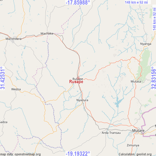
Rusape GPS coordinates[2]
18° 31' 40.26" South, 32° 7' 42.348" East
| Map corner | latitude | longitude |
|---|---|---|
| Upper-left | -17.85988°, | 31.42531° |
| Center: | -18.52785°, | 32.12843° |
| Lower-right: | -19.19322°, | 32.83156° |
| Map W x H: | 148.3×148.3 km | = 92.1×92.1mi |
| max Lat: | -16.03333° ⇑55.4% North |
| Rusape: | -18.52785° |
| min Lat: | ⇓44.6% South -22.21667° |
| min Long | Rusape | max Long |
| 25.83066° | 32.12843° | 32.86667° |
| W 87.7%⇐ | ⇒12.3% E |
Elevation
Elevation of Rusape is 1415 m = 4642 ft, and this is 217.3 m = 713 ft above average elevation for this country.
| Max E: |
1706 m = 5597 ft | 21.5% |
| Rusape | 1415 m 4642 ft | |
| Avg. | 1197.7 m = 3929 ft | |
Min E: |
402 m = 1319 ft | 78.5% |
See also: Zimbabwe elevation on elevation.city.
Geographical zone
Rusape is located in South Torrid zone (between Equator and Tropic of Capricorn). Distance of this Southern Tropic circle is 545.8 km =339.1 mi to South.| Distance of | km | miles | from Rusape |
|---|---|---|---|
| Equator | 2060.1 | 1280.1 | to North |
| Tropic Capricorn | 545.8 | 339.1 | to South |
| Antarctic Circle | 5341.1 | 3318.8 | to South |
| South Pole | 7947 | 4938 | to South |


Nearby cities:
15 places around Rusape: (largest is in red/bold)
• Chitungwiza
125.1 km =77.7 mi,  297°
297°
• Dorowa Mining Lease
71.9 km =44.7 mi,  213°
213°
• Epworth
125.6 km =78 mi, 304°
• Harare
137.7 km =85.6 mi, 304°
• Headlands
29 km =18 mi,  343°
343°
• Macheke
52.3 km =32.5 mi,  325°
325°
• Marondera
71.8 km =44.6 mi, 302°
• Murehwa
104.9 km =65.2 mi, 339°
• Mutare
75.4 km =46.9 mi,  130°
130°
• Mutoko
126.2 km =78.4 mi,  4°
4°
• Nyanga
74.2 km =46.1 mi,  62°
62°
• Nyazura
20.2 km =12.6 mi,  168°
168°
• Odzi
56.4 km =35 mi,  148°
148°
• Penhalonga
72.3 km =44.9 mi,  123°
123°
• Ruwa
117.2 km =72.8 mi,  307°
307°
Sources, notices
• [Note1] Compared only with cities in Zimbabwe existing in our database
• [Src1] Map data: © OpenStreetMap contributors (CC-BY-SA)
• [Src2] Other city data from geonames.org with taken over terms of usage.
• [Src3] Geographical zone / Annual Mean Temperature by Robert A. Rohde @ Wikipedia
