Odzi geodata
Odzi (Manicaland) is a populated place; located in Zimbabwe in Africa/Harare (GMT+2) time zone. With population of 3,438 people, there are 48 cities with bigger population in this country. Compared to other cities in Zimbabwe, 64.6% of cities are located further ↑North; 92.3% of cities are located further ←West and 80% of cities have higher elevation than Odzi. Note1


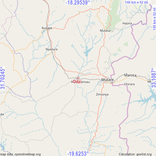
Odzi GPS coordinates[2]
18° 57' 42.012" South, 32° 24' 20.052" East
| Map corner | latitude | longitude |
|---|---|---|
| Upper-left | -18.29539°, | 31.70245° |
| Center: | -18.96167°, | 32.40557° |
| Lower-right: | -19.6253°, | 33.1087° |
| Map W x H: | 147.9×147.9 km | = 91.9×91.9mi |
| max Lat: | -16.03333° ⇑64.6% North |
| Odzi: | -18.96167° |
| min Lat: | ⇓35.4% South -22.21667° |
| min Long | Odzi | max Long |
| 25.83066° | 32.40557° | 32.86667° |
| W 92.3%⇐ | ⇒7.7% E |
Elevation
Elevation of Odzi is 1005 m = 3297 ft, and this is 192.7 m = 632 ft below average elevation for this country.
| Max E: |
1706 m = 5597 ft | 80% |
| Avg. | 1197.7 m = 3929 ft | |
| Odzi | 1005 m = 3297 ft | |
Min E: |
402 m = 1319 ft | 20% |
See also: Zimbabwe elevation on elevation.city.
Geographical zone
Odzi is located in South Torrid zone (between Equator and Tropic of Capricorn). Distance of this Southern Tropic circle is 497.6 km =309.2 mi to South.| Distance of | km | miles | from Odzi |
|---|---|---|---|
| Equator | 2108.3 | 1310 | to North |
| Tropic Capricorn | 497.6 | 309.2 | to South |
| Antarctic Circle | 5292.8 | 3288.8 | to South |
| South Pole | 7898.7 | 4908 | to South |


Nearby cities:
15 places around Odzi: (largest is in red/bold)
• Chimanimani
105 km =65.2 mi,  152°
152°
• Chipinge
138.3 km =85.9 mi,  170°
170°
• Chivhu
159.3 km =99 mi,  267°
267°
• Dorowa Mining Lease
69.9 km =43.4 mi,  260°
260°
• Headlands
84.7 km =52.6 mi,  333°
333°
• Macheke
108.7 km =67.5 mi, 327°
• Marondera
124.7 km =77.5 mi,  313°
313°
• Murehwa
160.6 km =99.8 mi,  335°
335°
• Mutare
27.9 km =17.3 mi,  92°
92°
• Mutoko
175 km =108.7 mi,  353°
353°
• Nyanga
90.4 km =56.2 mi,  23°
23°
• Nyazura
37.9 km =23.5 mi,  318°
318°
• Penhalonga
31.7 km =19.7 mi,  75°
75°
• Rusape
56.4 km =35 mi, 328°
• Ruwa
170.9 km =106.2 mi, 314°
Sources, notices
• [Note1] Compared only with cities in Zimbabwe existing in our database
• [Src1] Map data: © OpenStreetMap contributors (CC-BY-SA)
• [Src2] Other city data from geonames.org with taken over terms of usage.
• [Src3] Geographical zone / Annual Mean Temperature by Robert A. Rohde @ Wikipedia
