Mutare geodata
Mutare (Manicaland) is a seat of a first-order administrative division; located in Zimbabwe in Africa/Harare (GMT+2) time zone. With population of 184,205 people, there are 3 cities with bigger population in this country. Compared to other cities in Zimbabwe, 66.2% of cities are located further ↑North; 95.4% of cities are located further ←West and 66.2% of cities have higher elevation than Mutare. Note1


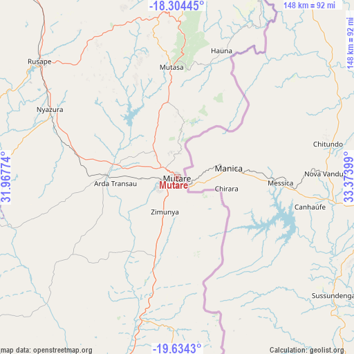
Mutare GPS coordinates[2]
18° 58' 14.52" South, 32° 40' 15.096" East
| Map corner | latitude | longitude |
|---|---|---|
| Upper-left | -18.30445°, | 31.96774° |
| Center: | -18.9707°, | 32.67086° |
| Lower-right: | -19.6343°, | 33.37399° |
| Map W x H: | 147.9×147.9 km | = 91.9×91.9mi |
| max Lat: | -16.03333° ⇑66.2% North |
| Mutare: | -18.9707° |
| min Lat: | ⇓33.8% South -22.21667° |
| min Long | Mutare | max Long |
| 25.83066° | 32.67086° | 32.86667° |
| W 95.4%⇐ | ⇒4.6% E |
Elevation
Elevation of Mutare is 1116 m = 3661 ft, and this is 81.7 m = 268 ft below average elevation for this country.
| Max E: |
1706 m = 5597 ft | 66.2% |
| Avg. | 1197.7 m = 3929 ft | |
| Mutare | 1116 m = 3661 ft | |
Min E: |
402 m = 1319 ft | 33.8% |
See also: Mutare elevation on elevation.city.
Geographical zone
Mutare is located in South Torrid zone (between Equator and Tropic of Capricorn). Distance of this Southern Tropic circle is 496.6 km =308.6 mi to South.| Distance of | km | miles | from Mutare |
|---|---|---|---|
| Equator | 2109.3 | 1310.7 | to North |
| Tropic Capricorn | 496.6 | 308.6 | to South |
| Antarctic Circle | 5291.8 | 3288.2 | to South |
| South Pole | 7897.7 | 4907.4 | to South |


Nearby cities:
15 places around Mutare: (largest is in red/bold)
• Chimanimani
94.5 km =58.7 mi,  167°
167°
• Chipinge
135.5 km =84.2 mi,  182°
182°
• Chivhu
187.1 km =116.3 mi,  268°
268°
• Dorowa Mining Lease
97.4 km =60.5 mi,  263°
263°
• Headlands
101 km =62.8 mi,  319°
319°
• Macheke
126.7 km =78.7 mi, 316°
• Marondera
146.7 km =91.2 mi,  306°
306°
• Murehwa
174.8 km =108.6 mi,  327°
327°
• Mutoko
181.2 km =112.6 mi,  344°
344°
• Nyanga
84.3 km =52.4 mi,  5°
5°
• Nyazura
60.6 km =37.7 mi,  299°
299°
• Odzi
27.9 km =17.3 mi, 272°
• Penhalonga
9.3 km =5.8 mi,  17°
17°
• Rusape
75.4 km =46.9 mi, 310°
• Ruwa
192.6 km =119.7 mi, 308°
Sources, notices
• [Note1] Compared only with cities in Zimbabwe existing in our database
• [Src1] Map data: © OpenStreetMap contributors (CC-BY-SA)
• [Src2] Other city data from geonames.org with taken over terms of usage.
• [Src3] Geographical zone / Annual Mean Temperature by Robert A. Rohde @ Wikipedia
