Penhalonga geodata
Penhalonga (Manicaland) is a populated place; located in Zimbabwe in Africa/Harare (GMT+2) time zone. With population of 7,681 people, there are 38 cities with bigger population in this country. Compared to other cities in Zimbabwe, 60% of cities are located further ↑North; 96.9% of cities are located further ←West and 67.7% of cities have lower elevation than Penhalonga. Note1


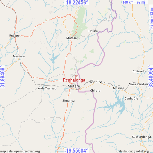
Penhalonga GPS coordinates[2]
18° 53' 28.032" South, 32° 41' 52.116" East
| Map corner | latitude | longitude |
|---|---|---|
| Upper-left | -18.22456°, | 31.99469° |
| Center: | -18.89112°, | 32.69781° |
| Lower-right: | -19.55504°, | 33.40094° |
| Map W x H: | 147.9×147.9 km | = 91.9×91.9mi |
| max Lat: | -16.03333° ⇑60% North |
| Penhalonga: | -18.89112° |
| min Lat: | ⇓40% South -22.21667° |
| min Long | Penhalonga | max Long |
| 25.83066° | 32.69781° | 32.86667° |
| W 96.9%⇐ | ⇒3.1% E |
Elevation
Elevation of Penhalonga is 1364 m = 4475 ft, and this is 166.3 m = 546 ft above average elevation for this country.
| Max E: |
1706 m = 5597 ft | 32.3% |
| Penhalonga | 1364 m 4475 ft | |
| Avg. | 1197.7 m = 3929 ft | |
Min E: |
402 m = 1319 ft | 67.7% |
See also: Zimbabwe elevation on elevation.city.
Geographical zone
Penhalonga is located in South Torrid zone (between Equator and Tropic of Capricorn). Distance of this Southern Tropic circle is 505.4 km =314 mi to South.| Distance of | km | miles | from Penhalonga |
|---|---|---|---|
| Equator | 2100.5 | 1305.2 | to North |
| Tropic Capricorn | 505.4 | 314 | to South |
| Antarctic Circle | 5300.7 | 3293.7 | to South |
| South Pole | 7906.6 | 4912.9 | to South |


Nearby cities:
15 places around Penhalonga: (largest is in red/bold)
• Chimanimani
102.6 km =63.8 mi,  170°
170°
• Chipinge
144.4 km =89.7 mi,  183°
183°
• Chivhu
190.4 km =118.3 mi,  265°
265°
• Dorowa Mining Lease
101.6 km =63.1 mi,  258°
258°
• Headlands
96.4 km =59.9 mi,  315°
315°
• Macheke
122.5 km =76.1 mi,  313°
313°
• Marondera
144.1 km =89.5 mi,  303°
303°
• Murehwa
169 km =105 mi,  325°
325°
• Mutare
9.3 km =5.8 mi,  197°
197°
• Mutoko
173.4 km =107.7 mi,  343°
343°
• Nyanga
75.2 km =46.7 mi,  4°
4°
• Nyazura
59.5 km =37 mi,  290°
290°
• Odzi
31.7 km =19.7 mi, 255°
• Rusape
72.3 km =44.9 mi, 303°
• Ruwa
189.5 km =117.7 mi, 305°
Sources, notices
• [Note1] Compared only with cities in Zimbabwe existing in our database
• [Src1] Map data: © OpenStreetMap contributors (CC-BY-SA)
• [Src2] Other city data from geonames.org with taken over terms of usage.
• [Src3] Geographical zone / Annual Mean Temperature by Robert A. Rohde @ Wikipedia
