Nyazura geodata
Nyazura (Manicaland) is a populated place; located in Zimbabwe in Africa/Harare (GMT+2) time zone. With population of 2,110 people, there are 55 cities with bigger population in this country. Compared to other cities in Zimbabwe, 58.5% of cities are located further ↑North; 89.2% of cities are located further ←West and 53.8% of cities have lower elevation than Nyazura. Note1


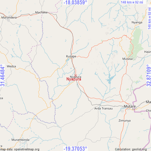
Nyazura GPS coordinates[2]
18° 42' 21.132" South, 32° 10' 4.656" East
| Map corner | latitude | longitude |
|---|---|---|
| Upper-left | -18.03859°, | 31.46484° |
| Center: | -18.70587°, | 32.16796° |
| Lower-right: | -19.37053°, | 32.87109° |
| Map W x H: | 148.1×148.1 km | = 92×92mi |
| max Lat: | -16.03333° ⇑58.5% North |
| Nyazura: | -18.70587° |
| min Lat: | ⇓41.5% South -22.21667° |
| min Long | Nyazura | max Long |
| 25.83066° | 32.16796° | 32.86667° |
| W 89.2%⇐ | ⇒10.8% E |
Elevation
Elevation of Nyazura is 1243 m = 4078 ft, and this is 45.3 m = 149 ft above average elevation for this country.
| Max E: |
1706 m = 5597 ft | 46.2% |
| Nyazura | 1243 m 4078 ft | |
| Avg. | 1197.7 m = 3929 ft | |
Min E: |
402 m = 1319 ft | 53.8% |
See also: Zimbabwe elevation on elevation.city.
Geographical zone
Nyazura is located in South Torrid zone (between Equator and Tropic of Capricorn). Distance of this Southern Tropic circle is 526 km =326.8 mi to South.| Distance of | km | miles | from Nyazura |
|---|---|---|---|
| Equator | 2079.9 | 1292.4 | to North |
| Tropic Capricorn | 526 | 326.8 | to South |
| Antarctic Circle | 5321.3 | 3306.5 | to South |
| South Pole | 7927.2 | 4925.7 | to South |


Nearby cities:
15 places around Nyazura: (largest is in red/bold)
• Chimanimani
142.1 km =88.3 mi,  148°
148°
• Chitungwiza
138.7 km =86.2 mi,  303°
303°
• Chivhu
138.7 km =86.2 mi,  255°
255°
• Dorowa Mining Lease
59.5 km =37 mi,  227°
227°
• Epworth
140.8 km =87.5 mi,  310°
310°
• Headlands
49.2 km =30.6 mi,  345°
345°
• Macheke
71.4 km =44.4 mi,  331°
331°
• Marondera
87 km =54.1 mi, 311°
• Murehwa
124.9 km =77.6 mi,  341°
341°
• Mutare
60.6 km =37.7 mi,  119°
119°
• Nyanga
82 km =51 mi,  48°
48°
• Odzi
37.9 km =23.5 mi,  138°
138°
• Penhalonga
59.5 km =37 mi,  110°
110°
• Rusape
20.2 km =12.6 mi, 348°
• Ruwa
133.2 km =82.8 mi, 312°
Sources, notices
• [Note1] Compared only with cities in Zimbabwe existing in our database
• [Src1] Map data: © OpenStreetMap contributors (CC-BY-SA)
• [Src2] Other city data from geonames.org with taken over terms of usage.
• [Src3] Geographical zone / Annual Mean Temperature by Robert A. Rohde @ Wikipedia
