Chimanimani geodata
Chimanimani (Manicaland) is a populated place; located in Zimbabwe in Africa/Harare (GMT+2) time zone. With population of 2,752 people, there are 51 cities with bigger population in this country. Compared to other cities in Zimbabwe, 83.1% of cities are located further ↑North; 100% of cities are located further ←West and 96.9% of cities have lower elevation than Chimanimani. Note1


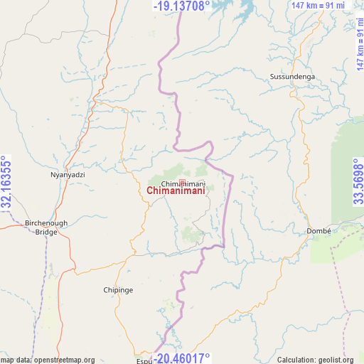
Chimanimani GPS coordinates[2]
19° 48' 0" South, 32° 52' 0.012" East
| Map corner | latitude | longitude |
|---|---|---|
| Upper-left | -19.13708°, | 32.16355° |
| Center: | -19.8°, | 32.86667° |
| Lower-right: | -20.46017°, | 33.5698° |
| Map W x H: | 147.1×147.1 km | = 91.4×91.4mi |
| max Lat: | -16.03333° ⇑83.1% North |
| Chimanimani: | -19.8° |
| min Lat: | ⇓16.9% South -22.21667° |
| min Long | Chimanimani | max Long |
| 25.83066° | 32.86667° | 32.86667° |
| W 100%⇐ | ⇒0% E |
Elevation
Elevation of Chimanimani is 1565 m = 5135 ft, and this is 367.3 m = 1205 ft above average elevation for this country.
| Max E: |
1706 m = 5597 ft | 3.1% |
| Chimanimani | 1565 m 5135 ft | |
| Avg. | 1197.7 m = 3929 ft | |
Min E: |
402 m = 1319 ft | 96.9% |
See also: Zimbabwe elevation on elevation.city.
Geographical zone
Chimanimani is located in South Torrid zone (between Equator and Tropic of Capricorn). Distance of this Southern Tropic circle is 404.4 km =251.3 mi to South.| Distance of | km | miles | from Chimanimani |
|---|---|---|---|
| Equator | 2201.6 | 1368 | to North |
| Tropic Capricorn | 404.4 | 251.3 | to South |
| Antarctic Circle | 5199.6 | 3230.9 | to South |
| South Pole | 7805.5 | 4850.1 | to South |


Nearby cities:
15 places around Chimanimani: (largest is in red/bold)
• Chipinge
50.1 km =31.1 mi,  210°
210°
• Chiredzi
187 km =116.2 mi,  221°
221°
• Chivhu
224.4 km =139.4 mi,  292°
292°
• Dorowa Mining Lease
142.7 km =88.7 mi,  304°
304°
• Headlands
189.7 km =117.9 mi,  333°
333°
• Macheke
213.4 km =132.6 mi, 329°
• Marondera
226.6 km =140.8 mi,  322°
322°
• Mashava
250.6 km =155.7 mi,  263°
263°
• Masvingo
215.1 km =133.7 mi, 262°
• Mutare
94.5 km =58.7 mi,  347°
347°
• Nyanga
176.5 km =109.7 mi,  356°
356°
• Nyazura
142.1 km =88.3 mi, 328°
• Odzi
105 km =65.2 mi, 332°
• Penhalonga
102.6 km =63.8 mi, 350°
• Rusape
161.3 km =100.2 mi, 331°
Sources, notices
• [Note1] Compared only with cities in Zimbabwe existing in our database
• [Src1] Map data: © OpenStreetMap contributors (CC-BY-SA)
• [Src2] Other city data from geonames.org with taken over terms of usage.
• [Src3] Geographical zone / Annual Mean Temperature by Robert A. Rohde @ Wikipedia
