Zaranj geodata
Zaranj (Nimroz) is a seat of a first-order administrative division; located in Afghanistan in Asia/Kabul (GMT+4.5) time zone. With population of 49,851 people, there are 21 cities with bigger population in this country. Compared to other cities in Afghanistan, 98.4% of cities are located further ↑North; 96.5% of cities are located further →East and 88.7% of cities have higher elevation than Zaranj. Note1


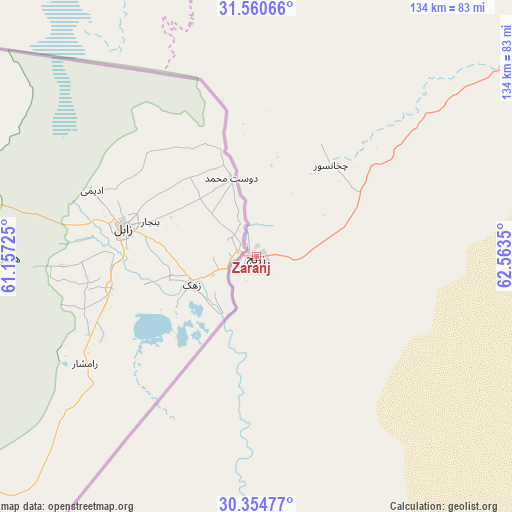
Zaranj GPS coordinates[2]
30° 57' 34.632" North, 61° 51' 37.332" East
| Map corner | latitude | longitude |
|---|---|---|
| Upper-left | 31.56066°, | 61.15725° |
| Center: | 30.95962°, | 61.86037° |
| Lower-right: | 30.35477°, | 62.5635° |
| Map W x H: | 134.1×134.1 km | = 83.3×83.3mi |
| max Lat: | 38.4435° ⇑98.4% North |
| Zaranj: | 30.95962° |
| min Lat: | ⇓1.6% South 30.15° |
| min Long | Zaranj | max Long |
| 61.06667° | 61.86037° | 72.318° |
| W 3.5%⇐ | ⇒96.5% E |
Elevation
Elevation of Zaranj is 489 m = 1604 ft, and this is 929.4 m = 3049 ft below average elevation for this country.
| Max E: |
3068 m = 10066 ft | 88.7% |
| Avg. | 1418.4 m = 4654 ft | |
| Zaranj | 489 m = 1604 ft | |
Min E: |
254 m = 833 ft | 11.3% |
See also: Zaranj elevation on elevation.city.
Geographical zone
Zaranj is located in North temperate zone (between Tropic of Cancer and the Arctic Circle). Distance of this Northern Tropic circle is 836.5 km =519.8 mi to South.| Distance of | km | miles | from Zaranj |
|---|---|---|---|
| North Pole | 6564.7 | 4079.1 | to North |
| Arctic Circle | 3958.8 | 2459.9 | to North |
| Tropic Cancer | 836.5 | 519.8 | to South |
| Equator | 3442.4 | 2139 | to South |


Nearby cities:
15 places around Zaranj: (largest is in red/bold)
• Anār Darah
201 km =124.9 mi,  354°
354°
• Dū Qal‘ah
137.2 km =85.3 mi,  343°
343°
• Farah
159.2 km =98.9 mi,  8°
8°
• Khān Neshīn
189.8 km =117.9 mi,  103°
103°
• Khāsh
108.8 km =67.6 mi,  54°
54°
• Kushkak
151.3 km =94 mi, 347°
• Lashkar Gāh
248.8 km =154.6 mi,  73°
73°
• Lāsh-e Juwayn
86.8 km =53.9 mi, 344°
• Markaz-e Ḩukūmat-e Darwēshān
223.1 km =138.6 mi,  85°
85°
• Markaz-e Ḩukūmat-e Sulţān-e Bakwāh
175.9 km =109.3 mi,  35°
35°
• Mīrābād
58.2 km =36.2 mi,  182°
182°
• Rūdbār
114.5 km =71.1 mi,  141°
141°
• Wāshēr
237.3 km =147.5 mi, 52°
• Ḩukūmat-e Nād ‘Alī
238.5 km =148.2 mi, 71°
• ‘Alāqahdārī Dīshū
149.4 km =92.8 mi,  113°
113°
In other languages:
- In France: Zarandj
- In German: Sarandsch
- In Russian: Зарани, Зарандж
- In Chinese: 扎兰季
Sources, notices
• [Note1] Compared only with cities in Afghanistan existing in our database
• [Src1] Map data: © OpenStreetMap contributors (CC-BY-SA)
• [Src2] Other city data from geonames.org with taken over terms of usage.
• [Src3] Geographical zone / Annual Mean Temperature by Robert A. Rohde @ Wikipedia
