Lāsh-e Juwayn geodata
Lāsh-e Juwayn (Farah) is a seat of a second-order administrative division; located in Afghanistan in Asia/Kabul (GMT+4.5) time zone. In our database, there are 93 cities with bigger population. Compared to other cities in Afghanistan, 94.5% of cities are located further ↑North; 98.1% of cities are located further →East and 87.5% of cities have higher elevation than Lāsh-e Juwayn. Note1


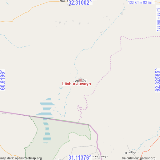
Lāsh-e Juwayn GPS coordinates[2]
31° 42' 49.752" North, 61° 37' 21.792" East
| Map corner | latitude | longitude |
|---|---|---|
| Upper-left | 32.31002°, | 60.9196° |
| Center: | 31.71382°, | 61.62272° |
| Lower-right: | 31.11376°, | 62.32585° |
| Map W x H: | 133×133 km | = 82.6×82.6mi |
| max Lat: | 38.4435° ⇑94.5% North |
| Lāsh-e Juwayn: | 31.71382° |
| min Lat: | ⇓5.5% South 30.15° |
| min Long | Lāsh-e Juwayn | max Long |
| 61.06667° | 61.62272° | 72.318° |
| W 1.9%⇐ | ⇒98.1% E |
Elevation
Elevation of Lāsh-e Juwayn is 513 m = 1683 ft, and this is 905.4 m = 2970 ft below average elevation for this country.
| Max E: |
3068 m = 10066 ft | 87.5% |
| Avg. | 1418.4 m = 4654 ft | |
| Lāsh-e Juwayn | 513 m = 1683 ft | |
Min E: |
254 m = 833 ft | 12.5% |
See also: Afghanistan elevation on elevation.city.
Geographical zone
Lāsh-e Juwayn is located in North temperate zone (between Tropic of Cancer and the Arctic Circle). Distance of this Northern Tropic circle is 920.3 km =571.8 mi to South.| Distance of | km | miles | from Lāsh-e Juwayn |
|---|---|---|---|
| North Pole | 6480.8 | 4027 | to North |
| Arctic Circle | 3874.9 | 2407.8 | to North |
| Tropic Cancer | 920.3 | 571.8 | to South |
| Equator | 3526.2 | 2191.1 | to South |


Nearby cities:
15 places around Lāsh-e Juwayn: (largest is in red/bold)
• Adraskan
223.2 km =138.7 mi,  15°
15°
• Anār Darah
116.2 km =72.2 mi,  1°
1°
• Dū Qal‘ah
50.5 km =31.4 mi,  340°
340°
• Farah
87 km =54.1 mi,  32°
32°
• Khāsh
112.5 km =69.9 mi,  100°
100°
• Kushk
178.6 km =111 mi,  9°
9°
• Kushkak
64.8 km =40.3 mi,  351°
351°
• Markaz-e Ḩukūmat-e Sulţān-e Bakwāh
138.2 km =85.9 mi,  64°
64°
• Mīrābād
143.5 km =89.2 mi,  171°
171°
• Qal‘ah-ye Kuhnah
217 km =134.8 mi, 62°
• Rūdbār
197.3 km =122.6 mi,  151°
151°
• Shīnḏanḏ
183.4 km =114 mi, 15°
• Wāshēr
218.9 km =136 mi,  74°
74°
• Zaranj
86.8 km =53.9 mi,  164°
164°
• ‘Alāqahdārī Dīshū
213.9 km =132.9 mi,  131°
131°
Sources, notices
• [Note1] Compared only with cities in Afghanistan existing in our database
• [Src1] Map data: © OpenStreetMap contributors (CC-BY-SA)
• [Src2] Other city data from geonames.org with taken over terms of usage.
• [Src3] Geographical zone / Annual Mean Temperature by Robert A. Rohde @ Wikipedia
