Khāsh geodata
Khāsh (Nimroz) is a populated place; located in Afghanistan in Asia/Kabul (GMT+4.5) time zone. With population of 15,133 people, there are 44 cities with bigger population in this country. Compared to other cities in Afghanistan, 97.4% of cities are located further ↑North; 92.3% of cities are located further →East and 85.2% of cities have higher elevation than Khāsh. Note1


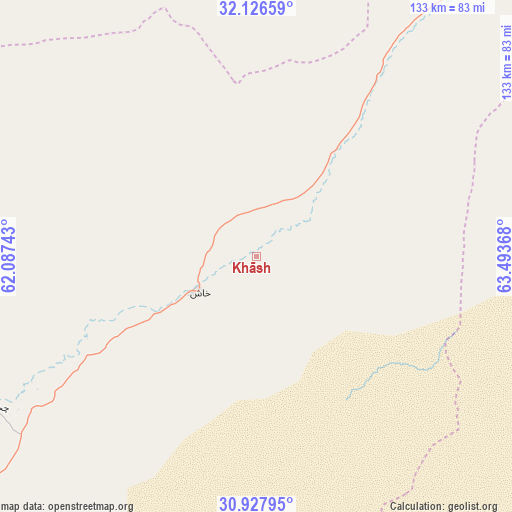
Khāsh GPS coordinates[2]
31° 31' 45.084" North, 62° 47' 25.98" East
| Map corner | latitude | longitude |
|---|---|---|
| Upper-left | 32.12659°, | 62.08743° |
| Center: | 31.52919°, | 62.79055° |
| Lower-right: | 30.92795°, | 63.49368° |
| Map W x H: | 133.3×133.3 km | = 82.8×82.8mi |
| max Lat: | 38.4435° ⇑97.4% North |
| Khāsh: | 31.52919° |
| min Lat: | ⇓2.6% South 30.15° |
| min Long | Khāsh | max Long |
| 61.06667° | 62.79055° | 72.318° |
| W 7.7%⇐ | ⇒92.3% E |
Elevation
Elevation of Khāsh is 579 m = 1900 ft, and this is 839.4 m = 2754 ft below average elevation for this country.
| Max E: |
3068 m = 10066 ft | 85.2% |
| Avg. | 1418.4 m = 4654 ft | |
| Khāsh | 579 m = 1900 ft | |
Min E: |
254 m = 833 ft | 14.8% |
See also: Afghanistan elevation on elevation.city.
Geographical zone
Khāsh is located in North temperate zone (between Tropic of Cancer and the Arctic Circle). Distance of this Northern Tropic circle is 899.8 km =559.1 mi to South.| Distance of | km | miles | from Khāsh |
|---|---|---|---|
| North Pole | 6501.3 | 4039.7 | to North |
| Arctic Circle | 3895.5 | 2420.6 | to North |
| Tropic Cancer | 899.8 | 559.1 | to South |
| Equator | 3505.7 | 2178.3 | to South |


Nearby cities:
15 places around Khāsh: (largest is in red/bold)
• Dū Qal‘ah
144.1 km =89.5 mi,  298°
298°
• Farah
113.5 km =70.5 mi,  325°
325°
• Khān Neshīn
144.7 km =89.9 mi,  138°
138°
• Kushkak
146.6 km =91.1 mi,  305°
305°
• Lashkar Gāh
150 km =93.2 mi,  87°
87°
• Lāsh-e Juwayn
112.5 km =69.9 mi,  280°
280°
• Markaz-e Ḩukūmat-e Darwēshān
140.4 km =87.2 mi,  108°
108°
• Markaz-e Ḩukūmat-e Sulţān-e Bakwāh
80.6 km =50.1 mi,  10°
10°
• Mīrābād
151.7 km =94.3 mi,  216°
216°
• Qal‘ah-ye Kuhnah
146.3 km =90.9 mi,  34°
34°
• Rūdbār
154.4 km =95.9 mi,  186°
186°
• Wāshēr
128.7 km =80 mi,  51°
51°
• Zaranj
108.8 km =67.6 mi,  234°
234°
• Ḩukūmat-e Nād ‘Alī
137.9 km =85.7 mi,  84°
84°
• ‘Alāqahdārī Dīshū
131.2 km =81.5 mi,  158°
158°
Sources, notices
• [Note1] Compared only with cities in Afghanistan existing in our database
• [Src1] Map data: © OpenStreetMap contributors (CC-BY-SA)
• [Src2] Other city data from geonames.org with taken over terms of usage.
• [Src3] Geographical zone / Annual Mean Temperature by Robert A. Rohde @ Wikipedia
