Farah geodata
Farah is a seat of a first-order administrative division; located in Afghanistan in Asia/Kabul (GMT+4.5) time zone. With population of 43,561 people, there are 28 cities with bigger population in this country. Compared to other cities in Afghanistan, 89.7% of cities are located further ↑North; 95.8% of cities are located further →East and 82% of cities have higher elevation than Farah. Note1


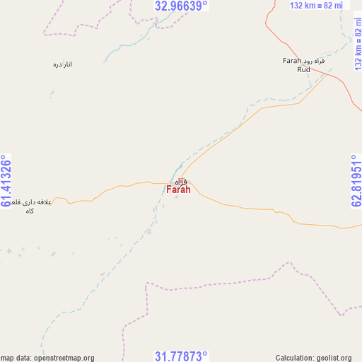
Farah GPS coordinates[2]
32° 22' 28.236" North, 62° 6' 58.968" East
| Map corner | latitude | longitude |
|---|---|---|
| Upper-left | 32.96639°, | 61.41326° |
| Center: | 32.37451°, | 62.11638° |
| Lower-right: | 31.77873°, | 62.81951° |
| Map W x H: | 132.1×132.1 km | = 82.1×82.1mi |
| max Lat: | 38.4435° ⇑89.7% North |
| Farah: | 32.37451° |
| min Lat: | ⇓10.3% South 30.15° |
| min Long | Farah | max Long |
| 61.06667° | 62.11638° | 72.318° |
| W 4.2%⇐ | ⇒95.8% E |
Elevation
Elevation of Farah is 662 m = 2172 ft, and this is 756.4 m = 2482 ft below average elevation for this country.
| Max E: |
3068 m = 10066 ft | 82% |
| Avg. | 1418.4 m = 4654 ft | |
| Farah | 662 m = 2172 ft | |
Min E: |
254 m = 833 ft | 18% |
See also: Farah elevation on elevation.city.
Geographical zone
Farah is located in North temperate zone (between Tropic of Cancer and the Arctic Circle). Distance of this Northern Tropic circle is 993.8 km =617.5 mi to South.| Distance of | km | miles | from Farah |
|---|---|---|---|
| North Pole | 6407.4 | 3981.4 | to North |
| Arctic Circle | 3801.5 | 2362.1 | to North |
| Tropic Cancer | 993.8 | 617.5 | to South |
| Equator | 3599.7 | 2236.7 | to South |


Nearby cities:
15 places around Farah: (largest is in red/bold)
• Adraskan
142.1 km =88.3 mi,  5°
5°
• Anār Darah
60.8 km =37.8 mi,  314°
314°
• Dasht-e Qal‘ah
176.9 km =109.9 mi,  65°
65°
• Dū Qal‘ah
68 km =42.3 mi,  247°
247°
• Guz̄arah
204.5 km =127.1 mi,  2°
2°
• Khāsh
113.5 km =70.5 mi,  145°
145°
• Kushk
103.6 km =64.4 mi,  351°
351°
• Kushkak
56.6 km =35.2 mi,  260°
260°
• Lāsh-e Juwayn
87 km =54.1 mi,  212°
212°
• Markaz-e Ḩukūmat-e Sulţān-e Bakwāh
79.7 km =49.5 mi,  100°
100°
• Qal‘ah-ye Fārsī
189 km =117.4 mi,  33°
33°
• Qal‘ah-ye Kuhnah
147.9 km =91.9 mi,  79°
79°
• Shīnḏanḏ
103.3 km =64.2 mi, 1°
• Wāshēr
164 km =101.9 mi,  94°
94°
• Zaranj
159.2 km =98.9 mi,  188°
188°
Sources, notices
• [Note1] Compared only with cities in Afghanistan existing in our database
• [Src1] Map data: © OpenStreetMap contributors (CC-BY-SA)
• [Src2] Other city data from geonames.org with taken over terms of usage.
• [Src3] Geographical zone / Annual Mean Temperature by Robert A. Rohde @ Wikipedia
