Lashkar Gāh geodata
Lashkar Gāh (Helmand) is a seat of a first-order administrative division; located in Afghanistan in Asia/Kabul (GMT+4.5) time zone. With population of 43,934 people, there are 26 cities with bigger population in this country. Compared to other cities in Afghanistan, 96.1% of cities are located further ↑North; 84.9% of cities are located further →East and 77.5% of cities have higher elevation than Lashkar Gāh. Note1


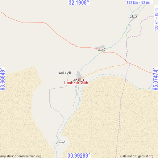
Lashkar Gāh GPS coordinates[2]
31° 35' 37.752" North, 64° 22' 17.796" East
| Map corner | latitude | longitude |
|---|---|---|
| Upper-left | 32.1908°, | 63.66849° |
| Center: | 31.59382°, | 64.37161° |
| Lower-right: | 30.99299°, | 65.07474° |
| Map W x H: | 133.2×133.2 km | = 82.8×82.8mi |
| max Lat: | 38.4435° ⇑96.1% North |
| Lashkar Gāh: | 31.59382° |
| min Lat: | ⇓3.9% South 30.15° |
| min Long | Lashkar Gāh | max Long |
| 61.06667° | 64.37161° | 72.318° |
| W 15.1%⇐ | ⇒84.9% E |
Elevation
Elevation of Lashkar Gāh is 786 m = 2579 ft, and this is 632.4 m = 2075 ft below average elevation for this country.
| Max E: |
3068 m = 10066 ft | 77.5% |
| Avg. | 1418.4 m = 4654 ft | |
| Lashkar Gāh | 786 m = 2579 ft | |
Min E: |
254 m = 833 ft | 22.5% |
See also: Lashkar Gāh elevation on elevation.city.
Geographical zone
Lashkar Gāh is located in North temperate zone (between Tropic of Cancer and the Arctic Circle). Distance of this Northern Tropic circle is 907 km =563.6 mi to South.| Distance of | km | miles | from Lashkar Gāh |
|---|---|---|---|
| North Pole | 6494.2 | 4035.3 | to North |
| Arctic Circle | 3888.3 | 2416.1 | to North |
| Tropic Cancer | 907 | 563.6 | to South |
| Equator | 3512.9 | 2182.8 | to South |


Nearby cities:
15 places around Lashkar Gāh: (largest is in red/bold)
• Babasakhib
122.3 km =76 mi,  86°
86°
• Chinār
83.9 km =52.1 mi,  55°
55°
• Gereshk
31.5 km =19.6 mi,  36°
36°
• Kandahār
126.8 km =78.8 mi, 89°
• Khān Neshīn
128.8 km =80 mi,  205°
205°
• Kishk-e Nakhūd
64.8 km =40.3 mi, 86°
• Markaz-e Ḩukūmat-e Darwēshān
54 km =33.6 mi,  198°
198°
• Mūsá Qal‘ah
101 km =62.8 mi,  20°
20°
• Now Zād
90.5 km =56.2 mi,  5°
5°
• Pāshmūl
100.7 km =62.6 mi, 92°
• Qal‘ah-ye Kuhnah
131.6 km =81.8 mi,  329°
329°
• Sangīn
69 km =42.9 mi, 39°
• Wāshēr
87.8 km =54.6 mi, 326°
• Zīārat-e Shāh Maqşūd
112.9 km =70.2 mi,  67°
67°
• Ḩukūmat-e Nād ‘Alī
13.6 km =8.5 mi,  293°
293°
Sources, notices
• [Note1] Compared only with cities in Afghanistan existing in our database
• [Src1] Map data: © OpenStreetMap contributors (CC-BY-SA)
• [Src2] Other city data from geonames.org with taken over terms of usage.
• [Src3] Geographical zone / Annual Mean Temperature by Robert A. Rohde @ Wikipedia
