Shīnḏanḏ geodata
Shīnḏanḏ (Herat) is a seat of a second-order administrative division; located in Afghanistan in Asia/Kabul (GMT+4.5) time zone. With population of 29,264 people, there are 30 cities with bigger population in this country. Compared to other cities in Afghanistan, 77.2% of cities are located further ↑North; 95.2% of cities are located further →East and 63.3% of cities have higher elevation than Shīnḏanḏ. Note1


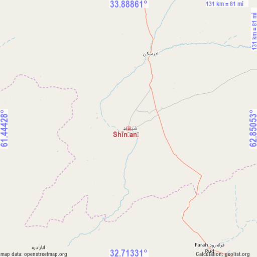
Shīnḏanḏ GPS coordinates[2]
33° 18' 10.584" North, 62° 8' 50.64" East
| Map corner | latitude | longitude |
|---|---|---|
| Upper-left | 33.88861°, | 61.44428° |
| Center: | 33.30294°, | 62.1474° |
| Lower-right: | 32.71331°, | 62.85053° |
| Map W x H: | 130.7×130.7 km | = 81.2×81.2mi |
| max Lat: | 38.4435° ⇑77.2% North |
| Shīnḏanḏ: | 33.30294° |
| min Lat: | ⇓22.8% South 30.15° |
| min Long | Shīnḏanḏ | max Long |
| 61.06667° | 62.1474° | 72.318° |
| W 4.8%⇐ | ⇒95.2% E |
Elevation
Elevation of Shīnḏanḏ is 1071 m = 3514 ft, and this is 347.4 m = 1140 ft below average elevation for this country.
| Max E: |
3068 m = 10066 ft | 63.3% |
| Avg. | 1418.4 m = 4654 ft | |
| Shīnḏanḏ | 1071 m = 3514 ft | |
Min E: |
254 m = 833 ft | 36.7% |
See also: Afghanistan elevation on elevation.city.
Geographical zone
Shīnḏanḏ is located in North temperate zone (between Tropic of Cancer and the Arctic Circle). Distance of this Northern Tropic circle is 1097 km =681.6 mi to South.| Distance of | km | miles | from Shīnḏanḏ |
|---|---|---|---|
| North Pole | 6304.1 | 3917.2 | to North |
| Arctic Circle | 3698.2 | 2298 | to North |
| Tropic Cancer | 1097 | 681.6 | to South |
| Equator | 3702.9 | 2300.9 | to South |


Nearby cities:
15 places around Shīnḏanḏ: (largest is in red/bold)
• Adraskan
39.8 km =24.7 mi,  16°
16°
• Anār Darah
76 km =47.2 mi,  217°
217°
• Chahār Burj
104.8 km =65.1 mi,  2°
2°
• Dū Qal‘ah
144.7 km =89.9 mi,  206°
206°
• Farah
103.3 km =64.2 mi,  181°
181°
• Ghōriyān
130.7 km =81.2 mi,  332°
332°
• Guz̄arah
101.3 km =62.9 mi, 3°
• Herāt
116.3 km =72.3 mi, 2°
• Injīl
111.4 km =69.2 mi, 4°
• Karukh
137.1 km =85.2 mi, 17°
• Kushk
18.2 km =11.3 mi,  267°
267°
• Kushkak
126.9 km =78.9 mi, 207°
• Markaz-e Ḩukūmat-e Sulţān-e Bakwāh
139.8 km =86.9 mi,  147°
147°
• Qal‘ah-ye Fārsī
115.2 km =71.6 mi,  62°
62°
• Zindah Jān
121.4 km =75.4 mi,  342°
342°
Sources, notices
• [Note1] Compared only with cities in Afghanistan existing in our database
• [Src1] Map data: © OpenStreetMap contributors (CC-BY-SA)
• [Src2] Other city data from geonames.org with taken over terms of usage.
• [Src3] Geographical zone / Annual Mean Temperature by Robert A. Rohde @ Wikipedia
