Qal‘ah-ye Kūf geodata
Qal‘ah-ye Kūf (Badakhshan) is a seat of a second-order administrative division; located in Afghanistan in Asia/Kabul (GMT+4.5) time zone. In our database, there are 93 cities with bigger population. Compared to other cities in Afghanistan, 99.4% of cities are located further ↓South; 88.7% of cities are located further ←West and 51.1% of cities have lower elevation than Qal‘ah-ye Kūf. Note1


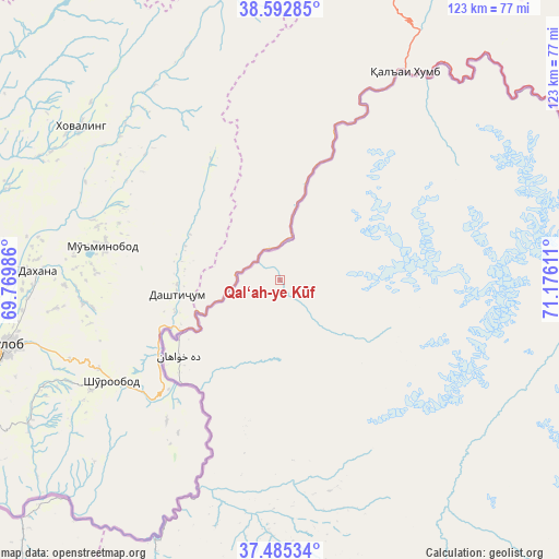
Qal‘ah-ye Kūf GPS coordinates[2]
38° 2' 28.284" North, 70° 28' 22.728" East
| Map corner | latitude | longitude |
|---|---|---|
| Upper-left | 38.59285°, | 69.76986° |
| Center: | 38.04119°, | 70.47298° |
| Lower-right: | 37.48534°, | 71.17611° |
| Map W x H: | 123.1×123.1 km | = 76.5×76.5mi |
| max Lat: | 38.4435° ⇑0.6% North |
| Qal‘ah-ye Kūf: | 38.04119° |
| min Lat: | ⇓99.4% South 30.15° |
| min Long | Qal‘ah-ye Kū | max Long |
| 61.06667° | 70.47298° | 72.318° |
| W 88.7%⇐ | ⇒11.3% E |
Elevation
Elevation of Qal‘ah-ye Kūf is 1383 m = 4537 ft, and this is 35.4 m = 116 ft below average elevation for this country.
| Max E: |
3068 m = 10066 ft | 48.9% |
| Avg. | 1418.4 m = 4654 ft | |
| Qal‘ah-ye Kūf | 1383 m = 4537 ft | |
Min E: |
254 m = 833 ft | 51.1% |
See also: Afghanistan elevation on elevation.city.
Geographical zone
Qal‘ah-ye Kūf is located in North temperate zone (between Tropic of Cancer and the Arctic Circle). Distance of this Northern Tropic circle is 1623.9 km =1009 mi to South.| Distance of | km | miles | from Qal‘ah-ye Kūf |
|---|---|---|---|
| North Pole | 5777.3 | 3589.8 | to North |
| Arctic Circle | 3171.4 | 1970.6 | to North |
| Tropic Cancer | 1623.9 | 1009 | to South |
| Equator | 4229.8 | 2628.3 | to South |


Nearby cities:
15 places around Qal‘ah-ye Kūf: (largest is in red/bold)
• Bahārak
121.7 km =75.6 mi,  161°
161°
• Bāzār-e Tashkān
130.1 km =80.8 mi,  187°
187°
• Chāh Āb
92 km =57.2 mi,  218°
218°
• Darqad
115.7 km =71.9 mi,  230°
230°
• Deh Khwāhān
27.9 km =17.3 mi, 232°
• Fayzabad
103.2 km =64.1 mi,  174°
174°
• March
57.1 km =35.5 mi,  182°
182°
• Māymay
64.1 km =39.8 mi,  50°
50°
• Nūsay
53.3 km =33.1 mi,  32°
32°
• Pas Pul
64.4 km =40 mi, 168°
• Rustāq
116.4 km =72.3 mi,  209°
209°
• Shahrān
120.3 km =74.8 mi, 168°
• Yangī Qal‘ah
99.2 km =61.6 mi, 229°
• Zīrakī
50.5 km =31.4 mi, 171°
• Ḩāfiz̧ Moghul
109.7 km =68.2 mi, 183°
Sources, notices
• [Note1] Compared only with cities in Afghanistan existing in our database
• [Src1] Map data: © OpenStreetMap contributors (CC-BY-SA)
• [Src2] Other city data from geonames.org with taken over terms of usage.
• [Src3] Geographical zone / Annual Mean Temperature by Robert A. Rohde @ Wikipedia
