Bahārak geodata
Bahārak (Badakhshan) is a seat of a second-order administrative division; located in Afghanistan in Asia/Kabul (GMT+4.5) time zone. In our database, there are 93 cities with bigger population. Compared to other cities in Afghanistan, 92.3% of cities are located further ↓South; 94.5% of cities are located further ←West and 56.6% of cities have lower elevation than Bahārak. Note1


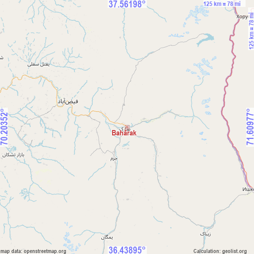
Bahārak GPS coordinates[2]
37° 0' 9.144" North, 70° 54' 23.904" East
| Map corner | latitude | longitude |
|---|---|---|
| Upper-left | 37.56198°, | 70.20352° |
| Center: | 37.00254°, | 70.90664° |
| Lower-right: | 36.43895°, | 71.60977° |
| Map W x H: | 124.9×124.9 km | = 77.6×77.6mi |
| max Lat: | 38.4435° ⇑7.7% North |
| Bahārak: | 37.00254° |
| min Lat: | ⇓92.3% South 30.15° |
| min Long | Bahārak | max Long |
| 61.06667° | 70.90664° | 72.318° |
| W 94.5%⇐ | ⇒5.5% E |
Elevation
Elevation of Bahārak is 1552 m = 5092 ft, and this is 133.6 m = 438 ft above average elevation for this country.
| Max E: |
3068 m = 10066 ft | 43.4% |
| Bahārak | 1552 m 5092 ft | |
| Avg. | 1418.4 m = 4654 ft | |
Min E: |
254 m = 833 ft | 56.6% |
See also: Afghanistan elevation on elevation.city.
Geographical zone
Bahārak is located in North temperate zone (between Tropic of Cancer and the Arctic Circle). Distance of this Northern Tropic circle is 1508.4 km =937.3 mi to South.| Distance of | km | miles | from Bahārak |
|---|---|---|---|
| North Pole | 5892.8 | 3661.6 | to North |
| Arctic Circle | 3286.9 | 2042.4 | to North |
| Tropic Cancer | 1508.4 | 937.3 | to South |
| Equator | 4114.3 | 2556.5 | to South |


Nearby cities:
15 places around Bahārak: (largest is in red/bold)
• Ashkāsham
66.1 km =41.1 mi,  122°
122°
• Bāzār-e Tashkān
57.6 km =35.8 mi,  256°
256°
• Chākarān
17.6 km =10.9 mi,  125°
125°
• Darāyim
48.9 km =30.4 mi,  252°
252°
• Fayzabad
31.6 km =19.6 mi,  293°
293°
• Ghurayd Gharamē
54.4 km =33.8 mi,  190°
190°
• Jurm
16.6 km =10.3 mi,  202°
202°
• Kalafgān
89.3 km =55.5 mi, 253°
• March
71.2 km =44.2 mi,  325°
325°
• Mashhad
74.5 km =46.3 mi, 253°
• Pas Pul
58.3 km =36.2 mi, 333°
• Shahrān
15.1 km =9.4 mi, 260°
• Zaybāk
65.5 km =40.7 mi,  143°
143°
• Zīrakī
72.5 km =45 mi, 334°
• Ḩāfiz̧ Moghul
45.3 km =28.1 mi,  277°
277°
Sources, notices
• [Note1] Compared only with cities in Afghanistan existing in our database
• [Src1] Map data: © OpenStreetMap contributors (CC-BY-SA)
• [Src2] Other city data from geonames.org with taken over terms of usage.
• [Src3] Geographical zone / Annual Mean Temperature by Robert A. Rohde @ Wikipedia
