Fayzabad geodata
Fayzabad (Badakhshan) is a seat of a first-order administrative division; located in Afghanistan in Asia/Kabul (GMT+4.5) time zone. With population of 44,421 people, there are 25 cities with bigger population in this country. Compared to other cities in Afghanistan, 94.2% of cities are located further ↓South; 89.4% of cities are located further ←West and 57.2% of cities have higher elevation than Fayzabad. Note1


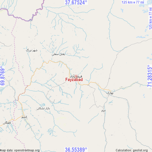
Fayzabad GPS coordinates[2]
37° 6' 59.904" North, 70° 34' 48.072" East
| Map corner | latitude | longitude |
|---|---|---|
| Upper-left | 37.67524°, | 69.8769° |
| Center: | 37.11664°, | 70.58002° |
| Lower-right: | 36.55389°, | 71.28315° |
| Map W x H: | 124.7×124.7 km | = 77.5×77.5mi |
| max Lat: | 38.4435° ⇑5.8% North |
| Fayzabad: | 37.11664° |
| min Lat: | ⇓94.2% South 30.15° |
| min Long | Fayzabad | max Long |
| 61.06667° | 70.58002° | 72.318° |
| W 89.4%⇐ | ⇒10.6% E |
Elevation
Elevation of Fayzabad is 1210 m = 3970 ft, and this is 208.4 m = 684 ft below average elevation for this country.
| Max E: |
3068 m = 10066 ft | 57.2% |
| Avg. | 1418.4 m = 4654 ft | |
| Fayzabad | 1210 m = 3970 ft | |
Min E: |
254 m = 833 ft | 42.8% |
See also: Fayzabad elevation on elevation.city.
Geographical zone
Fayzabad is located in North temperate zone (between Tropic of Cancer and the Arctic Circle). Distance of this Northern Tropic circle is 1521.1 km =945.2 mi to South.| Distance of | km | miles | from Fayzabad |
|---|---|---|---|
| North Pole | 5880.1 | 3653.7 | to North |
| Arctic Circle | 3274.2 | 2034.5 | to North |
| Tropic Cancer | 1521.1 | 945.2 | to South |
| Equator | 4127 | 2564.4 | to South |


Nearby cities:
15 places around Fayzabad: (largest is in red/bold)
• Bahārak
31.6 km =19.6 mi,  113°
113°
• Bāzār-e Tashkān
37.5 km =23.3 mi,  225°
225°
• Chāh Āb
74.6 km =46.4 mi,  294°
294°
• Chākarān
49 km =30.4 mi,  117°
117°
• Darāyim
32.8 km =20.4 mi,  212°
212°
• Ghurayd Gharamē
68.7 km =42.7 mi,  164°
164°
• Jurm
36 km =22.4 mi,  141°
141°
• Kalafgān
68.2 km =42.4 mi,  235°
235°
• March
47.2 km =29.3 mi,  345°
345°
• Mashhad
54 km =33.6 mi, 231°
• Pas Pul
39.8 km =24.7 mi,  4°
4°
• Rustāq
66.5 km =41.3 mi,  270°
270°
• Shahrān
20.8 km =12.9 mi, 137°
• Zīrakī
52.9 km =32.9 mi,  357°
357°
• Ḩāfiz̧ Moghul
17.3 km =10.7 mi,  247°
247°
Sources, notices
• [Note1] Compared only with cities in Afghanistan existing in our database
• [Src1] Map data: © OpenStreetMap contributors (CC-BY-SA)
• [Src2] Other city data from geonames.org with taken over terms of usage.
• [Src3] Geographical zone / Annual Mean Temperature by Robert A. Rohde @ Wikipedia
