Qal‘ah-ye Kuhnah geodata
Qal‘ah-ye Kuhnah (Farah) is a seat of a second-order administrative division; located in Afghanistan in Asia/Kabul (GMT+4.5) time zone. In our database, there are 93 cities with bigger population. Compared to other cities in Afghanistan, 87.1% of cities are located further ↑North; 89.1% of cities are located further →East and 52.1% of cities have lower elevation than Qal‘ah-ye Kuhnah. Note1


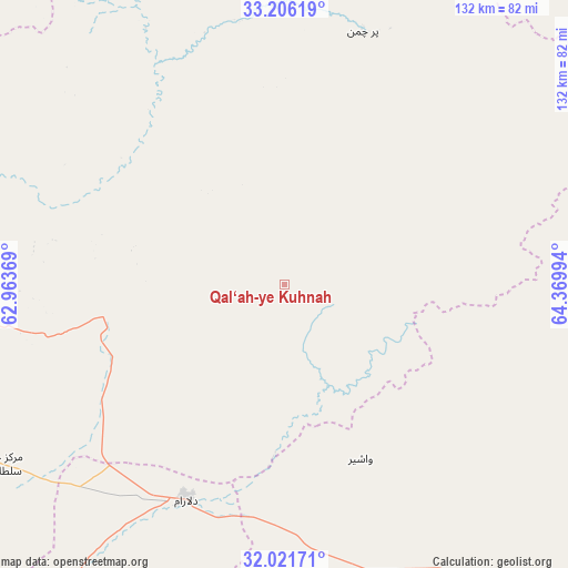
Qal‘ah-ye Kuhnah GPS coordinates[2]
32° 36' 57.276" North, 63° 40' 0.516" East
| Map corner | latitude | longitude |
|---|---|---|
| Upper-left | 33.20619°, | 62.96369° |
| Center: | 32.61591°, | 63.66681° |
| Lower-right: | 32.02171°, | 64.36994° |
| Map W x H: | 131.7×131.7 km | = 81.8×81.8mi |
| max Lat: | 38.4435° ⇑87.1% North |
| Qal‘ah-ye Kuhnah: | 32.61591° |
| min Lat: | ⇓12.9% South 30.15° |
| min Long | Qal‘ah-ye Kuh | max Long |
| 61.06667° | 63.66681° | 72.318° |
| W 10.9%⇐ | ⇒89.1% E |
Elevation
Elevation of Qal‘ah-ye Kuhnah is 1429 m = 4688 ft, and this is 10.6 m = 35 ft above average elevation for this country.
| Max E: |
3068 m = 10066 ft | 47.9% |
| Qal‘ah-ye Kuhnah | 1429 m 4688 ft | |
| Avg. | 1418.4 m = 4654 ft | |
Min E: |
254 m = 833 ft | 52.1% |
See also: Afghanistan elevation on elevation.city.
Geographical zone
Qal‘ah-ye Kuhnah is located in North temperate zone (between Tropic of Cancer and the Arctic Circle). Distance of this Northern Tropic circle is 1020.6 km =634.2 mi to South.| Distance of | km | miles | from Qal‘ah-ye Kuhnah |
|---|---|---|---|
| North Pole | 6380.5 | 3964.7 | to North |
| Arctic Circle | 3774.6 | 2345.4 | to North |
| Tropic Cancer | 1020.6 | 634.2 | to South |
| Equator | 3626.5 | 2253.4 | to South |


Nearby cities:
15 places around Qal‘ah-ye Kuhnah: (largest is in red/bold)
• Chinār
150.9 km =93.8 mi,  116°
116°
• Dasht-e Qal‘ah
48.8 km =30.3 mi,  19°
19°
• Farah
147.9 km =91.9 mi,  259°
259°
• Gereshk
122.6 km =76.2 mi,  136°
136°
• Khāsh
146.3 km =90.9 mi,  214°
214°
• Lashkar Gāh
131.6 km =81.8 mi,  149°
149°
• Markaz-e Ḩukūmat-e Sulţān-e Bakwāh
79.2 km =49.2 mi,  238°
238°
• Mūsá Qal‘ah
102.8 km =63.9 mi,  100°
100°
• Now Zād
78.9 km =49 mi,  107°
107°
• Qal‘ah-ye Fārsī
135.8 km =84.4 mi,  343°
343°
• Sangīn
125.3 km =77.9 mi, 118°
• Taywarah
122.8 km =76.3 mi,  34°
34°
• Tītān
120.9 km =75.1 mi,  8°
8°
• Wāshēr
44.2 km =27.5 mi,  156°
156°
• Ḩukūmat-e Nād ‘Alī
120.9 km =75.1 mi, 153°
Sources, notices
• [Note1] Compared only with cities in Afghanistan existing in our database
• [Src1] Map data: © OpenStreetMap contributors (CC-BY-SA)
• [Src2] Other city data from geonames.org with taken over terms of usage.
• [Src3] Geographical zone / Annual Mean Temperature by Robert A. Rohde @ Wikipedia
