Tsau geodata
Tsau is a populated place; located in Botswana in Africa/Gaborone (GMT+2) time zone. With population of 1,409 people, there are 72 cities with bigger population in this country. Compared to other cities in Botswana, 92.4% of cities are located further ↓South; 88.6% of cities are located further →East and 69.5% of cities have higher elevation than Tsau. Note1


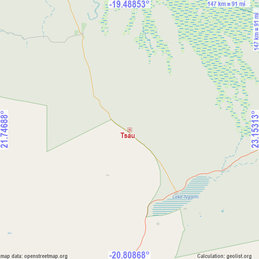
Tsau GPS coordinates[2]
20° 9' 0" South, 22° 27' 0" East
| Map corner | latitude | longitude |
|---|---|---|
| Upper-left | -19.48853°, | 21.74688° |
| Center: | -20.15°, | 22.45° |
| Lower-right: | -20.80868°, | 23.15313° |
| Map W x H: | 146.8×146.8 km | = 91.2×91.2mi |
| max Lat: | -17.80165° ⇑7.6% North |
| Tsau: | -20.15° |
| min Lat: | ⇓92.4% South -26.9° |
| min Long | Tsau | max Long |
| 20.06667° | 22.45° | 28.74946° |
| W 11.4%⇐ | ⇒88.6% E |
Elevation
Elevation of Tsau is 945 m = 3100 ft, and this is 70 m = 230 ft below average elevation for this country.
| Max E: |
1406 m = 4613 ft | 69.5% |
| Avg. | 1015 m = 3330 ft | |
| Tsau | 945 m = 3100 ft | |
Min E: |
676 m = 2218 ft | 30.5% |
See also: Botswana elevation on elevation.city.
Geographical zone
Tsau is located in South Torrid zone (between Equator and Tropic of Capricorn). Distance of this Southern Tropic circle is 365.4 km =227 mi to South.| Distance of | km | miles | from Tsau |
|---|---|---|---|
| Equator | 2240.5 | 1392.2 | to North |
| Tropic Capricorn | 365.4 | 227 | to South |
| Antarctic Circle | 5160.7 | 3206.7 | to South |
| South Pole | 7766.6 | 4825.9 | to South |


Nearby cities:
15 places around Tsau: (largest is in red/bold)
• Dekar
162.9 km =101.2 mi,  199°
199°
• Ghanzi
191.3 km =118.9 mi,  205°
205°
• Gweta
290.5 km =180.5 mi,  90°
90°
• Kachikau
305.8 km =190 mi,  43°
43°
• Kavimba
327.6 km =203.6 mi, 43°
• Letlhakane
355.7 km =221 mi,  113°
113°
• Manyana
369.2 km =229.4 mi,  191°
191°
• Maun
102.6 km =63.8 mi,  79°
79°
• Mopipi
278 km =172.7 mi, 114°
• Nokaneng
57.1 km =35.5 mi,  340°
340°
• Orapa
330.6 km =205.4 mi, 112°
• Rakops
221.3 km =137.5 mi,  116°
116°
• Sehithwa
44.9 km =27.9 mi,  141°
141°
• Shakawe
208.4 km =129.5 mi, 342°
• Toteng
58.2 km =36.2 mi, 116°
Sources, notices
• [Note1] Compared only with cities in Botswana existing in our database
• [Src1] Map data: © OpenStreetMap contributors (CC-BY-SA)
• [Src2] Other city data from geonames.org with taken over terms of usage.
• [Src3] Geographical zone / Annual Mean Temperature by Robert A. Rohde @ Wikipedia
