Mopipi geodata
Mopipi (Central) is a populated place; located in Botswana in Africa/Gaborone (GMT+2) time zone. With population of 3,301 people, there are 42 cities with bigger population in this country. Compared to other cities in Botswana, 79% of cities are located further ↓South; 73.3% of cities are located further →East and 84.8% of cities have higher elevation than Mopipi. Note1


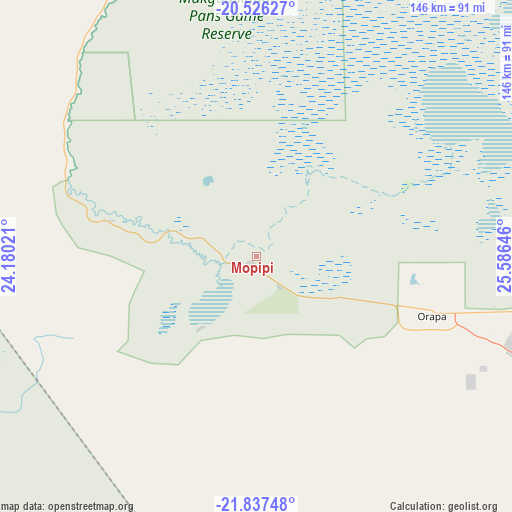
Mopipi GPS coordinates[2]
21° 10' 59.988" South, 24° 52' 59.988" East
| Map corner | latitude | longitude |
|---|---|---|
| Upper-left | -20.52627°, | 24.18021° |
| Center: | -21.18333°, | 24.88333° |
| Lower-right: | -21.83748°, | 25.58646° |
| Map W x H: | 145.8×145.8 km | = 90.6×90.6mi |
| max Lat: | -17.80165° ⇑21% North |
| Mopipi: | -21.18333° |
| min Lat: | ⇓79% South -26.9° |
| min Long | Mopipi | max Long |
| 20.06667° | 24.88333° | 28.74946° |
| W 26.7%⇐ | ⇒73.3% E |
Elevation
Elevation of Mopipi is 906 m = 2972 ft, and this is 109 m = 358 ft below average elevation for this country.
| Max E: |
1406 m = 4613 ft | 84.8% |
| Avg. | 1015 m = 3330 ft | |
| Mopipi | 906 m = 2972 ft | |
Min E: |
676 m = 2218 ft | 15.2% |
See also: Botswana elevation on elevation.city.
Geographical zone
Mopipi is located in South Torrid zone (between Equator and Tropic of Capricorn). Distance of this Southern Tropic circle is 250.6 km =155.7 mi to South.| Distance of | km | miles | from Mopipi |
|---|---|---|---|
| Equator | 2355.4 | 1463.6 | to North |
| Tropic Capricorn | 250.6 | 155.7 | to South |
| Antarctic Circle | 5045.8 | 3135.3 | to South |
| South Pole | 7651.7 | 4754.5 | to South |


Nearby cities:
15 places around Mopipi: (largest is in red/bold)
• Dukwe
172.7 km =107.3 mi,  67°
67°
• Gweta
117 km =72.7 mi,  18°
18°
• Letlhakane
77.9 km =48.4 mi,  109°
109°
• Makaleng
251 km =156 mi,  82°
82°
• Maun
202.8 km =126 mi,  311°
311°
• Moijabana
210.6 km =130.9 mi,  131°
131°
• Mosetse
189.7 km =117.9 mi, 75°
• Nata
172.7 km =107.3 mi,  51°
51°
• Orapa
53 km =32.9 mi, 105°
• Rakops
57.1 km =35.5 mi,  288°
288°
• Sebina
248.1 km =154.2 mi, 81°
• Sehithwa
238.9 km =148.4 mi, 289°
• Serowe
231.4 km =143.8 mi, 125°
• Sua
186.2 km =115.7 mi, 47°
• Toteng
219.8 km =136.6 mi, 293°
Sources, notices
• [Note1] Compared only with cities in Botswana existing in our database
• [Src1] Map data: © OpenStreetMap contributors (CC-BY-SA)
• [Src2] Other city data from geonames.org with taken over terms of usage.
• [Src3] Geographical zone / Annual Mean Temperature by Robert A. Rohde @ Wikipedia
