Kavimba geodata
Kavimba (Chobe) is a populated place; located in Botswana in Africa/Gaborone (GMT+2) time zone. With population of 566 people, there are 100 cities with bigger population in this country. Compared to other cities in Botswana, 99% of cities are located further ↓South; 77.1% of cities are located further →East and 75.2% of cities have higher elevation than Kavimba. Note1


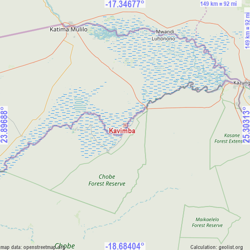
Kavimba GPS coordinates[2]
18° 1' 0.012" South, 24° 36' 0" East
| Map corner | latitude | longitude |
|---|---|---|
| Upper-left | -17.34677°, | 23.89688° |
| Center: | -18.01667°, | 24.6° |
| Lower-right: | -18.68404°, | 25.30313° |
| Map W x H: | 148.7×148.7 km | = 92.4×92.4mi |
| max Lat: | -17.80165° ⇑1% North |
| Kavimba: | -18.01667° |
| min Lat: | ⇓99% South -26.9° |
| min Long | Kavimba | max Long |
| 20.06667° | 24.6° | 28.74946° |
| W 22.9%⇐ | ⇒77.1% E |
Elevation
Elevation of Kavimba is 930 m = 3051 ft, and this is 85 m = 279 ft below average elevation for this country.
| Max E: |
1406 m = 4613 ft | 75.2% |
| Avg. | 1015 m = 3330 ft | |
| Kavimba | 930 m = 3051 ft | |
Min E: |
676 m = 2218 ft | 24.8% |
See also: Botswana elevation on elevation.city.
Geographical zone
Kavimba is located in South Torrid zone (between Equator and Tropic of Capricorn). Distance of this Southern Tropic circle is 602.7 km =374.5 mi to South.| Distance of | km | miles | from Kavimba |
|---|---|---|---|
| Equator | 2003.3 | 1244.8 | to North |
| Tropic Capricorn | 602.7 | 374.5 | to South |
| Antarctic Circle | 5397.9 | 3354.1 | to South |
| South Pole | 8003.8 | 4973.3 | to South |


Nearby cities:
15 places around Kavimba: (largest is in red/bold)
• Dukwe
343.2 km =213.3 mi,  146°
146°
• Gweta
249.9 km =155.3 mi,  164°
164°
• Kachikau
21.8 km =13.5 mi,  220°
220°
• Kasane
63.9 km =39.7 mi,  68°
68°
• Maun
251.6 km =156.3 mi,  209°
209°
• Mopipi
353.3 km =219.5 mi,  175°
175°
• Nata
295.8 km =183.8 mi, 145°
• Nokaneng
306.5 km =190.5 mi,  233°
233°
• Pandamatenga
122.4 km =76.1 mi,  117°
117°
• Rakops
335.2 km =208.3 mi, 184°
• Sehithwa
336.6 km =209.2 mi, 215°
• Shakawe
293.9 km =182.6 mi,  262°
262°
• Sua
281.8 km =175.1 mi,  143°
143°
• Toteng
315.1 km =195.8 mi, 213°
• Tsau
327.6 km =203.6 mi, 223°
Sources, notices
• [Note1] Compared only with cities in Botswana existing in our database
• [Src1] Map data: © OpenStreetMap contributors (CC-BY-SA)
• [Src2] Other city data from geonames.org with taken over terms of usage.
• [Src3] Geographical zone / Annual Mean Temperature by Robert A. Rohde @ Wikipedia
