Nokaneng geodata
Nokaneng (North-West) is a populated place; located in Botswana in Africa/Gaborone (GMT+2) time zone. With population of 1,763 people, there are 62 cities with bigger population in this country. Compared to other cities in Botswana, 95.2% of cities are located further ↓South; 89.5% of cities are located further →East and 65.7% of cities have higher elevation than Nokaneng. Note1


Nokaneng GPS coordinates[2]
19° 40' 0.012" South, 22° 16' 0.012" East
| Map corner | latitude | longitude |
|---|---|---|
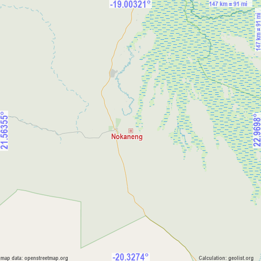
| Upper-left | -19.00321°, | 21.56355° |
| Center: | -19.66667°, | 22.26667° |
| Lower-right: | -20.3274°, | 22.9698° |
| Map W x H: | 147.2×147.2 km | = 91.5×91.5mi |
| max Lat: | -17.80165° ⇑4.8% North |
| Nokaneng: | -19.66667° |
| min Lat: | ⇓95.2% South -26.9° |
| min Long | Nokaneng | max Long |
| 20.06667° | 22.26667° | 28.74946° |
| W 10.5%⇐ | ⇒89.5% E |
Elevation
Elevation of Nokaneng is 957 m = 3140 ft, and this is 58 m = 190 ft below average elevation for this country.
| Max E: |
1406 m = 4613 ft | 65.7% |
| Avg. | 1015 m = 3330 ft | |
| Nokaneng | 957 m = 3140 ft | |
Min E: |
676 m = 2218 ft | 34.3% |
See also: Botswana elevation on elevation.city.
Geographical zone
Nokaneng is located in South Torrid zone (between Equator and Tropic of Capricorn). Distance of this Southern Tropic circle is 419.2 km =260.5 mi to South.| Distance of | km | miles | from Nokaneng |
|---|---|---|---|
| Equator | 2186.7 | 1358.8 | to North |
| Tropic Capricorn | 419.2 | 260.5 | to South |
| Antarctic Circle | 5214.4 | 3240.1 | to South |
| South Pole | 7820.3 | 4859.3 | to South |


Nearby cities:
15 places around Nokaneng: (largest is in red/bold)
• Dekar
210.4 km =130.7 mi,  189°
189°
• Ghanzi
234.9 km =146 mi,  195°
195°
• Gweta
315.4 km =196 mi,  100°
100°
• Kachikau
285.2 km =177.2 mi,  54°
54°
• Kasane
368.5 km =229 mi,  55°
55°
• Kavimba
306.5 km =190.5 mi, 53°
• Maun
125.3 km =77.9 mi,  106°
106°
• Mopipi
320.6 km =199.2 mi,  121°
121°
• Orapa
371.9 km =231.1 mi, 119°
• Pandamatenga
375.1 km =233.1 mi,  70°
70°
• Rakops
265.3 km =164.8 mi, 124°
• Sehithwa
100.6 km =62.5 mi,  152°
152°
• Shakawe
151.4 km =94.1 mi,  342°
342°
• Toteng
107 km =66.5 mi,  138°
138°
• Tsau
57.1 km =35.5 mi,  160°
160°
Sources, notices
• [Note1] Compared only with cities in Botswana existing in our database
• [Src1] Map data: © OpenStreetMap contributors (CC-BY-SA)
• [Src2] Other city data from geonames.org with taken over terms of usage.
• [Src3] Geographical zone / Annual Mean Temperature by Robert A. Rohde @ Wikipedia
