Maun geodata
Maun (North-West) is a seat of a first-order administrative division; located in Botswana in Africa/Gaborone (GMT+2) time zone. With population of 49,945 people, there are 4 cities with bigger population in this country. Compared to other cities in Botswana, 94.3% of cities are located further ↓South; 82.9% of cities are located further →East and 67.6% of cities have higher elevation than Maun. Note1


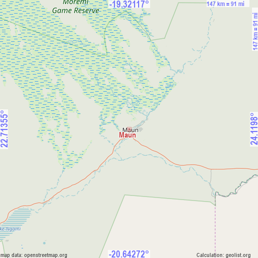
Maun GPS coordinates[2]
19° 58' 59.988" South, 23° 25' 0.012" East
| Map corner | latitude | longitude |
|---|---|---|
| Upper-left | -19.32117°, | 22.71355° |
| Center: | -19.98333°, | 23.41667° |
| Lower-right: | -20.64272°, | 24.1198° |
| Map W x H: | 146.9×146.9 km | = 91.3×91.3mi |
| max Lat: | -17.80165° ⇑5.7% North |
| Maun: | -19.98333° |
| min Lat: | ⇓94.3% South -26.9° |
| min Long | Maun | max Long |
| 20.06667° | 23.41667° | 28.74946° |
| W 17.1%⇐ | ⇒82.9% E |
Elevation
Elevation of Maun is 947 m = 3107 ft, and this is 68 m = 223 ft below average elevation for this country.
| Max E: |
1406 m = 4613 ft | 67.6% |
| Avg. | 1015 m = 3330 ft | |
| Maun | 947 m = 3107 ft | |
Min E: |
676 m = 2218 ft | 32.4% |
See also: Maun elevation on elevation.city.
Geographical zone
Maun is located in South Torrid zone (between Equator and Tropic of Capricorn). Distance of this Southern Tropic circle is 384 km =238.6 mi to South.| Distance of | km | miles | from Maun |
|---|---|---|---|
| Equator | 2221.9 | 1380.6 | to North |
| Tropic Capricorn | 384 | 238.6 | to South |
| Antarctic Circle | 5179.2 | 3218.2 | to South |
| South Pole | 7785.1 | 4837.4 | to South |


Nearby cities:
15 places around Maun: (largest is in red/bold)
• Dekar
231.3 km =143.7 mi,  221°
221°
• Ghanzi
265 km =164.7 mi, 223°
• Gweta
191 km =118.7 mi,  96°
96°
• Kachikau
230.2 km =143 mi,  28°
28°
• Kavimba
251.6 km =156.3 mi, 29°
• Letlhakane
276.7 km =171.9 mi,  125°
125°
• Mopipi
202.8 km =126 mi, 131°
• Nokaneng
125.3 km =77.9 mi,  286°
286°
• Orapa
251.8 km =156.5 mi, 125°
• Pandamatenga
282.9 km =175.8 mi,  55°
55°
• Rakops
151.7 km =94.3 mi,  139°
139°
• Sehithwa
90.7 km =56.4 mi,  233°
233°
• Shakawe
244.3 km =151.8 mi,  317°
317°
• Toteng
66 km =41 mi, 227°
• Tsau
102.6 km =63.8 mi,  259°
259°
Sources, notices
• [Note1] Compared only with cities in Botswana existing in our database
• [Src1] Map data: © OpenStreetMap contributors (CC-BY-SA)
• [Src2] Other city data from geonames.org with taken over terms of usage.
• [Src3] Geographical zone / Annual Mean Temperature by Robert A. Rohde @ Wikipedia
