Sehithwa geodata
Sehithwa (North-West) is a populated place; located in Botswana in Africa/Gaborone (GMT+2) time zone. With population of 1,614 people, there are 68 cities with bigger population in this country. Compared to other cities in Botswana, 88.6% of cities are located further ↓South; 86.7% of cities are located further →East and 73.3% of cities have higher elevation than Sehithwa. Note1


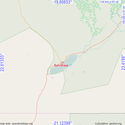
Sehithwa GPS coordinates[2]
20° 28' 0.012" South, 22° 43' 0.012" East
| Map corner | latitude | longitude |
|---|---|---|
| Upper-left | -19.80653°, | 22.01355° |
| Center: | -20.46667°, | 22.71667° |
| Lower-right: | -21.12399°, | 23.4198° |
| Map W x H: | 146.5×146.5 km | = 91×91mi |
| max Lat: | -17.80165° ⇑11.4% North |
| Sehithwa: | -20.46667° |
| min Lat: | ⇓88.6% South -26.9° |
| min Long | Sehithwa | max Long |
| 20.06667° | 22.71667° | 28.74946° |
| W 13.3%⇐ | ⇒86.7% E |
Elevation
Elevation of Sehithwa is 931 m = 3054 ft, and this is 84 m = 276 ft below average elevation for this country.
| Max E: |
1406 m = 4613 ft | 73.3% |
| Avg. | 1015 m = 3330 ft | |
| Sehithwa | 931 m = 3054 ft | |
Min E: |
676 m = 2218 ft | 26.7% |
See also: Botswana elevation on elevation.city.
Geographical zone
Sehithwa is located in South Torrid zone (between Equator and Tropic of Capricorn). Distance of this Southern Tropic circle is 330.2 km =205.2 mi to South.| Distance of | km | miles | from Sehithwa |
|---|---|---|---|
| Equator | 2275.7 | 1414.1 | to North |
| Tropic Capricorn | 330.2 | 205.2 | to South |
| Antarctic Circle | 5125.5 | 3184.8 | to South |
| South Pole | 7731.4 | 4804.1 | to South |


Nearby cities:
15 places around Sehithwa: (largest is in red/bold)
• Dekar
143.8 km =89.4 mi,  214°
214°
• Ghanzi
176.3 km =109.5 mi,  219°
219°
• Gweta
264.3 km =164.2 mi,  83°
83°
• Kachikau
314.8 km =195.6 mi,  35°
35°
• Kavimba
336.6 km =209.2 mi, 35°
• Letlhakane
316.7 km =196.8 mi,  109°
109°
• Manyana
342.1 km =212.6 mi,  197°
197°
• Maun
90.7 km =56.4 mi,  53°
53°
• Mopipi
238.9 km =148.4 mi, 109°
• Nokaneng
100.6 km =62.5 mi,  332°
332°
• Orapa
291.8 km =181.3 mi, 108°
• Rakops
181.8 km =113 mi, 109°
• Shakawe
251 km =156 mi,  338°
338°
• Toteng
26 km =16.2 mi,  69°
69°
• Tsau
44.9 km =27.9 mi,  321°
321°
Sources, notices
• [Note1] Compared only with cities in Botswana existing in our database
• [Src1] Map data: © OpenStreetMap contributors (CC-BY-SA)
• [Src2] Other city data from geonames.org with taken over terms of usage.
• [Src3] Geographical zone / Annual Mean Temperature by Robert A. Rohde @ Wikipedia
