Sua geodata
Sua (Central) is a populated place; located in Botswana in Africa/Gaborone (GMT+2) time zone. With population of 3,141 people, there are 43 cities with bigger population in this country. Compared to other cities in Botswana, 93.3% of cities are located further ↓South; 61% of cities are located further ←West and 77.1% of cities have higher elevation than Sua. Note1


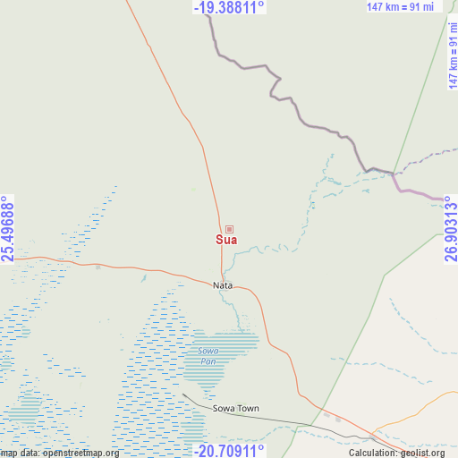
Sua GPS coordinates[2]
20° 3' 0" South, 26° 12' 0" East
| Map corner | latitude | longitude |
|---|---|---|
| Upper-left | -19.38811°, | 25.49688° |
| Center: | -20.05°, | 26.2° |
| Lower-right: | -20.70911°, | 26.90313° |
| Map W x H: | 146.9×146.9 km | = 91.3×91.3mi |
| max Lat: | -17.80165° ⇑6.7% North |
| Sua: | -20.05° |
| min Lat: | ⇓93.3% South -26.9° |
| min Long | Sua | max Long |
| 20.06667° | 26.2° | 28.74946° |
| W 61%⇐ | ⇒39% E |
Elevation
Elevation of Sua is 929 m = 3048 ft, and this is 86 m = 282 ft below average elevation for this country.
| Max E: |
1406 m = 4613 ft | 77.1% |
| Avg. | 1015 m = 3330 ft | |
| Sua | 929 m = 3048 ft | |
Min E: |
676 m = 2218 ft | 22.9% |
See also: Botswana elevation on elevation.city.
Geographical zone
Sua is located in South Torrid zone (between Equator and Tropic of Capricorn). Distance of this Southern Tropic circle is 376.6 km =234 mi to South.| Distance of | km | miles | from Sua |
|---|---|---|---|
| Equator | 2229.4 | 1385.3 | to North |
| Tropic Capricorn | 376.6 | 234 | to South |
| Antarctic Circle | 5171.8 | 3213.6 | to South |
| South Pole | 7777.7 | 4832.8 | to South |


Nearby cities:
15 places around Sua: (largest is in red/bold)
• Dukwe
63.5 km =39.5 mi,  159°
159°
• Francistown
184.5 km =114.6 mi,  132°
132°
• Gweta
102 km =63.4 mi,  261°
261°
• Kalakamati
130.6 km =81.2 mi,  117°
117°
• Letlhakane
164.4 km =102.2 mi,  202°
202°
• Makaleng
147.2 km =91.5 mi, 129°
• Masunga
145 km =90.1 mi, 116°
• Mathambgwane
157.6 km =97.9 mi, 131°
• Mopipi
186.2 km =115.7 mi,  227°
227°
• Mosetse
90.9 km =56.5 mi,  148°
148°
• Nata
18.6 km =11.6 mi,  185°
185°
• Orapa
164.4 km =102.2 mi,  211°
211°
• Pandamatenga
179.6 km =111.6 mi,  340°
340°
• Sebina
142.2 km =88.4 mi, 129°
• Tonota
202.9 km =126.1 mi,  139°
139°
Sources, notices
• [Note1] Compared only with cities in Botswana existing in our database
• [Src1] Map data: © OpenStreetMap contributors (CC-BY-SA)
• [Src2] Other city data from geonames.org with taken over terms of usage.
• [Src3] Geographical zone / Annual Mean Temperature by Robert A. Rohde @ Wikipedia
