Pandamatenga geodata
Pandamatenga (North-West) is a populated place; located in Botswana in Africa/Gaborone (GMT+2) time zone. With population of 1,685 people, there are 64 cities with bigger population in this country. Compared to other cities in Botswana, 96.2% of cities are located further ↓South; 61.9% of cities are located further →East and 69.5% of cities have lower elevation than Pandamatenga. Note1


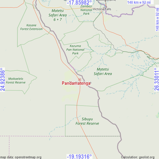
Pandamatenga GPS coordinates[2]
18° 31' 40.044" South, 25° 37' 37.128" East
| Map corner | latitude | longitude |
|---|---|---|
| Upper-left | -17.85982°, | 24.92386° |
| Center: | -18.52779°, | 25.62698° |
| Lower-right: | -19.19316°, | 26.33011° |
| Map W x H: | 148.3×148.3 km | = 92.1×92.1mi |
| max Lat: | -17.80165° ⇑3.8% North |
| Pandamatenga: | -18.52779° |
| min Lat: | ⇓96.2% South -26.9° |
| min Long | Pandamatenga | max Long |
| 20.06667° | 25.62698° | 28.74946° |
| W 38.1%⇐ | ⇒61.9% E |
Elevation
Elevation of Pandamatenga is 1072 m = 3517 ft, and this is 57 m = 187 ft above average elevation for this country.
| Max E: |
1406 m = 4613 ft | 30.5% |
| Pandamatenga | 1072 m 3517 ft | |
| Avg. | 1015 m = 3330 ft | |
Min E: |
676 m = 2218 ft | 69.5% |
See also: Botswana elevation on elevation.city.
Geographical zone
Pandamatenga is located in South Torrid zone (between Equator and Tropic of Capricorn). Distance of this Southern Tropic circle is 545.8 km =339.1 mi to South.| Distance of | km | miles | from Pandamatenga |
|---|---|---|---|
| Equator | 2060.1 | 1280.1 | to North |
| Tropic Capricorn | 545.8 | 339.1 | to South |
| Antarctic Circle | 5341.1 | 3318.8 | to South |
| South Pole | 7947 | 4938 | to South |


Nearby cities:
15 places around Pandamatenga: (largest is in red/bold)
• Dukwe
243.1 km =151.1 mi,  160°
160°
• Gweta
188.7 km =117.3 mi,  192°
192°
• Kachikau
128.9 km =80.1 mi,  288°
288°
• Kalakamati
289.5 km =179.9 mi,  142°
142°
• Kasane
94.6 km =58.8 mi,  328°
328°
• Kavimba
122.4 km =76.1 mi,  297°
297°
• Masunga
301.3 km =187.2 mi, 140°
• Maun
282.9 km =175.8 mi,  235°
235°
• Mopipi
305.3 km =189.7 mi, 194°
• Mosetse
269.3 km =167.3 mi, 156°
• Nata
196.6 km =122.2 mi, 162°
• Orapa
310.6 km =193 mi,  184°
184°
• Rakops
307.4 km =191 mi,  205°
205°
• Sebina
310.6 km =193 mi,  146°
146°
• Sua
179.6 km =111.6 mi, 160°
Sources, notices
• [Note1] Compared only with cities in Botswana existing in our database
• [Src1] Map data: © OpenStreetMap contributors (CC-BY-SA)
• [Src2] Other city data from geonames.org with taken over terms of usage.
• [Src3] Geographical zone / Annual Mean Temperature by Robert A. Rohde @ Wikipedia
