Nata geodata
Nata (Central) is a populated place; located in Botswana in Africa/Gaborone (GMT+2) time zone. With population of 4,794 people, there are 31 cities with bigger population in this country. Compared to other cities in Botswana, 90.5% of cities are located further ↓South; 60% of cities are located further ←West and 83.8% of cities have higher elevation than Nata. Note1


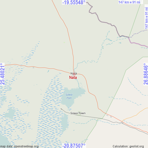
Nata GPS coordinates[2]
20° 13' 0.012" South, 26° 10' 59.988" East
| Map corner | latitude | longitude |
|---|---|---|
| Upper-left | -19.55548°, | 25.48021° |
| Center: | -20.21667°, | 26.18333° |
| Lower-right: | -20.87507°, | 26.88646° |
| Map W x H: | 146.7×146.7 km | = 91.2×91.2mi |
| max Lat: | -17.80165° ⇑9.5% North |
| Nata: | -20.21667° |
| min Lat: | ⇓90.5% South -26.9° |
| min Long | Nata | max Long |
| 20.06667° | 26.18333° | 28.74946° |
| W 60%⇐ | ⇒40% E |
Elevation
Elevation of Nata is 912 m = 2992 ft, and this is 103 m = 338 ft below average elevation for this country.
| Max E: |
1406 m = 4613 ft | 83.8% |
| Avg. | 1015 m = 3330 ft | |
| Nata | 912 m = 2992 ft | |
Min E: |
676 m = 2218 ft | 16.2% |
See also: Botswana elevation on elevation.city.
Geographical zone
Nata is located in South Torrid zone (between Equator and Tropic of Capricorn). Distance of this Southern Tropic circle is 358 km =222.5 mi to South.| Distance of | km | miles | from Nata |
|---|---|---|---|
| Equator | 2247.9 | 1396.8 | to North |
| Tropic Capricorn | 358 | 222.5 | to South |
| Antarctic Circle | 5153.3 | 3202.1 | to South |
| South Pole | 7759.2 | 4821.3 | to South |


Nearby cities:
15 places around Nata: (largest is in red/bold)
• Dukwe
47.5 km =29.5 mi,  149°
149°
• Francistown
173.8 km =108 mi,  127°
127°
• Gweta
99.2 km =61.6 mi,  272°
272°
• Kalakamati
124.7 km =77.5 mi,  109°
109°
• Letlhakane
146.7 km =91.2 mi,  204°
204°
• Makaleng
137.4 km =85.4 mi,  123°
123°
• Masunga
139.4 km =86.6 mi, 108°
• Mathambgwane
147.3 km =91.5 mi, 125°
• Mopipi
172.7 km =107.3 mi,  231°
231°
• Mosetse
76.7 km =47.7 mi,  140°
140°
• Orapa
147.8 km =91.8 mi,  214°
214°
• Pandamatenga
196.6 km =122.2 mi,  342°
342°
• Sebina
132.5 km =82.3 mi, 123°
• Sua
18.6 km =11.6 mi,  5°
5°
• Tonota
190.3 km =118.2 mi, 135°
Sources, notices
• [Note1] Compared only with cities in Botswana existing in our database
• [Src1] Map data: © OpenStreetMap contributors (CC-BY-SA)
• [Src2] Other city data from geonames.org with taken over terms of usage.
• [Src3] Geographical zone / Annual Mean Temperature by Robert A. Rohde @ Wikipedia
