Kasane geodata
Kasane (Chobe) is a seat of a first-order administrative division; located in Botswana in Africa/Gaborone (GMT+2) time zone. With population of 9,250 people, there are 20 cities with bigger population in this country. Compared to other cities in Botswana, 100% of cities are located further ↓South; 71.4% of cities are located further →East and 99% of cities have higher elevation than Kasane. Note1


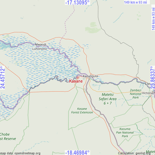
Kasane GPS coordinates[2]
17° 48' 5.94" South, 25° 9' 36.864" East
| Map corner | latitude | longitude |
|---|---|---|
| Upper-left | -17.13095°, | 24.45712° |
| Center: | -17.80165°, | 25.16024° |
| Lower-right: | -18.46984°, | 25.86337° |
| Map W x H: | 148.9×148.9 km | = 92.5×92.5mi |
| max Lat: | -17.80165° ⇑0% North |
| Kasane: | -17.80165° |
| min Lat: | ⇓100% South -26.9° |
| min Long | Kasane | max Long |
| 20.06667° | 25.16024° | 28.74946° |
| W 28.6%⇐ | ⇒71.4% E |
Elevation
Elevation of Kasane is 684 m = 2244 ft, and this is 331 m = 1086 ft below average elevation for this country.
| Max E: |
1406 m = 4613 ft | 99% |
| Avg. | 1015 m = 3330 ft | |
| Kasane | 684 m = 2244 ft | |
Min E: |
676 m = 2218 ft | 1% |
See also: Botswana elevation on elevation.city.
Geographical zone
Kasane is located in South Torrid zone (between Equator and Tropic of Capricorn). Distance of this Southern Tropic circle is 626.6 km =389.4 mi to South.| Distance of | km | miles | from Kasane |
|---|---|---|---|
| Equator | 1979.4 | 1229.9 | to North |
| Tropic Capricorn | 626.6 | 389.4 | to South |
| Antarctic Circle | 5421.8 | 3368.9 | to South |
| South Pole | 8027.7 | 4988.2 | to South |


Nearby cities:
15 places around Kasane: (largest is in red/bold)
• Dukwe
336.3 km =209 mi,  156°
156°
• Gweta
264.9 km =164.6 mi,  178°
178°
• Kachikau
83.8 km =52.1 mi,  241°
241°
• Kalakamati
383.7 km =238.4 mi,  143°
143°
• Kavimba
63.9 km =39.7 mi,  248°
248°
• Maun
304.1 km =189 mi,  217°
217°
• Mopipi
377.1 km =234.3 mi, 184°
• Mosetse
363.2 km =225.7 mi,  154°
154°
• Nata
289.3 km =179.8 mi, 158°
• Nokaneng
368.5 km =229 mi, 235°
• Pandamatenga
94.6 km =58.8 mi, 148°
• Rakops
367.8 km =228.5 mi,  193°
193°
• Shakawe
356.3 km =221.4 mi,  259°
259°
• Sua
272.9 km =169.6 mi, 156°
• Toteng
369.2 km =229.4 mi, 218°
Sources, notices
• [Note1] Compared only with cities in Botswana existing in our database
• [Src1] Map data: © OpenStreetMap contributors (CC-BY-SA)
• [Src2] Other city data from geonames.org with taken over terms of usage.
• [Src3] Geographical zone / Annual Mean Temperature by Robert A. Rohde @ Wikipedia
