Yokadouma geodata
Yokadouma (East) is a populated place; located in Cameroon in Africa/Douala (GMT+1) time zone. With population of 13,287 people, there are 64 cities with bigger population in this country. Compared to other cities in Cameroon, 91.8% of cities are located further ↑North; 99.2% of cities are located further ←West and 60.7% of cities have higher elevation than Yokadouma. Note1


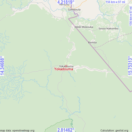
Yokadouma GPS coordinates[2]
3° 31' 0.012" North, 15° 3' 0" East
| Map corner | latitude | longitude |
|---|---|---|
| Upper-left | 4.21819°, | 14.34688° |
| Center: | 3.51667°, | 15.05° |
| Lower-right: | 2.81462°, | 15.75313° |
| Map W x H: | 156.1×156.1 km | = 97×97mi |
| max Lat: | 12.57535° ⇑91.8% North |
| Yokadouma: | 3.51667° |
| min Lat: | ⇓8.2% South 2.35° |
| min Long | Yokadouma | max Long |
| 8.8724° | 15.05° | 15.23288° |
| W 99.2%⇐ | ⇒0.8% E |
Elevation
Elevation of Yokadouma is 523 m = 1716 ft, and this is 150.9 m = 495 ft below average elevation for this country.
| Max E: |
1687 m = 5535 ft | 60.7% |
| Avg. | 673.9 m = 2211 ft | |
| Yokadouma | 523 m = 1716 ft | |
Min E: |
1 m = 3 ft | 39.3% |
See also: Cameroon elevation on elevation.city.
Geographical zone
Yokadouma is located in North Torrid zone (between Equator and Tropic of Cancer). Distance of Equator is 391 km =243 mi to South.| Distance of | km | miles | from Yokadouma |
|---|---|---|---|
| North Pole | 9616 | 5975.1 | to North |
| Arctic Circle | 7010.2 | 4355.9 | to North |
| Tropic Cancer | 2214.9 | 1376.3 | to North |
| Equator | 391 | 243 | to South |


Nearby cities:
15 places around Yokadouma: (largest is in red/bold)
• Abong Mbang
213.5 km =132.7 mi,  284°
284°
• Akonolinga
311.9 km =193.8 mi, 275°
• Batouri
127 km =78.9 mi,  323°
323°
• Bertoua
191.9 km =119.2 mi,  307°
307°
• Bélabo
249.9 km =155.3 mi, 309°
• Bétaré Oya
255.2 km =158.6 mi,  335°
335°
• Dimako
190.7 km =118.5 mi,  300°
300°
• Doumé
194.6 km =120.9 mi,  294°
294°
• Garoua Boulaï
268.9 km =167.1 mi,  348°
348°
• Mbang
224.3 km =139.4 mi, 301°
• Meïganga
343.8 km =213.6 mi, 346°
• Minta
276.3 km =171.7 mi, 295°
• Nanga Eboko
324.6 km =201.7 mi, 293°
• Ndelele
59.9 km =37.2 mi, 346°
• Sangmélima
346.6 km =215.4 mi,  259°
259°
Sources, notices
• [Note1] Compared only with cities in Cameroon existing in our database
• [Src1] Map data: © OpenStreetMap contributors (CC-BY-SA)
• [Src2] Other city data from geonames.org with taken over terms of usage.
• [Src3] Geographical zone / Annual Mean Temperature by Robert A. Rohde @ Wikipedia
