Djohong geodata
Djohong (Adamaoua) is a populated place; located in Cameroon in Africa/Douala (GMT+1) time zone. With population of 4,813 people, there are 105 cities with bigger population in this country. Compared to other cities in Cameroon, 82.8% of cities are located further ↓South; 96.7% of cities are located further ←West and 86.9% of cities have lower elevation than Djohong. Note1


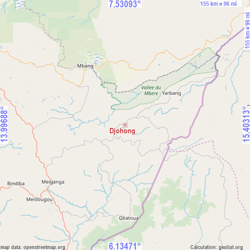
Djohong GPS coordinates[2]
6° 49' 59.988" North, 14° 42' 0" East
| Map corner | latitude | longitude |
|---|---|---|
| Upper-left | 7.53093°, | 13.99688° |
| Center: | 6.83333°, | 14.7° |
| Lower-right: | 6.13471°, | 15.40313° |
| Map W x H: | 155.2×155.2 km | = 96.4×96.4mi |
| max Lat: | 12.57535° ⇑17.2% North |
| Djohong: | 6.83333° |
| min Lat: | ⇓82.8% South 2.35° |
| min Long | Djohong | max Long |
| 8.8724° | 14.7° | 15.23288° |
| W 96.7%⇐ | ⇒3.3% E |
Elevation
Elevation of Djohong is 1271 m = 4170 ft, and this is 597.1 m = 1959 ft above average elevation for this country.
| Max E: |
1687 m = 5535 ft | 13.1% |
| Djohong | 1271 m 4170 ft | |
| Avg. | 673.9 m = 2211 ft | |
Min E: |
1 m = 3 ft | 86.9% |
See also: Cameroon elevation on elevation.city.
Geographical zone
Djohong is located in North Torrid zone (between Equator and Tropic of Cancer). Distance of Equator is 759.8 km =472.1 mi to South.| Distance of | km | miles | from Djohong |
|---|---|---|---|
| North Pole | 9247.3 | 5746 | to North |
| Arctic Circle | 6641.4 | 4126.8 | to North |
| Tropic Cancer | 1846.1 | 1147.1 | to North |
| Equator | 759.8 | 472.1 | to South |


Nearby cities:
15 places around Djohong: (largest is in red/bold)
• Batouri
269.4 km =167.4 mi,  187°
187°
• Bertoua
274.9 km =170.8 mi,  204°
204°
• Bélabo
261.9 km =162.7 mi,  216°
216°
• Bélel
38 km =23.6 mi,  309°
309°
• Bétaré Oya
153.1 km =95.1 mi,  206°
206°
• Garoua Boulaï
106.9 km =66.4 mi, 188°
• Lagdo
272.3 km =169.2 mi,  335°
335°
• Mbang
292.3 km =181.6 mi, 211°
• Meïganga
56.5 km =35.1 mi,  231°
231°
• Ngaoundéré
134.8 km =83.8 mi,  294°
294°
• Poli
243.3 km =151.2 mi,  318°
318°
• Rey Bouba
212.4 km =132 mi, 344°
• Tcholliré
184 km =114.3 mi, 341°
• Tibati
232.4 km =144.4 mi,  259°
259°
• Tignère
233.8 km =145.3 mi,  284°
284°
Sources, notices
• [Note1] Compared only with cities in Cameroon existing in our database
• [Src1] Map data: © OpenStreetMap contributors (CC-BY-SA)
• [Src2] Other city data from geonames.org with taken over terms of usage.
• [Src3] Geographical zone / Annual Mean Temperature by Robert A. Rohde @ Wikipedia
