Macará geodata
Macará (Loja) is a populated place; located in Ecuador in America/Guayaquil (GMT-5) time zone. With population of 13,035 people, there are 70 cities with bigger population in this country. Compared to other cities in Ecuador, 100% of cities are located further ↑North; 72.7% of cities are located further →East and 55.4% of cities have lower elevation than Macará. Note1


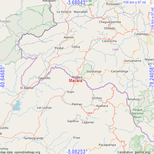
Macará GPS coordinates[2]
4° 22' 54.516" South, 79° 56' 37.32" West
| Map corner | latitude | longitude |
|---|---|---|
| Upper-left | -3.68043°, | -80.64683° |
| Center: | -4.38181°, | -79.9437° |
| Lower-right: | -5.08253°, | -79.24058° |
| Map W x H: | 155.9×155.9 km | = 96.9×96.9mi |
| max Lat: | 1.35251° ⇑100% North |
| Macará: | -4.38181° |
| min Lat: | ⇓0% South -4.38181° |
| min Long | Macará | max Long |
| -90.96654° | -79.9437° | -76.89528° |
| W 27.3%⇐ | ⇒72.7% E |
Elevation
Elevation of Macará is 450 m = 1476 ft, and this is 495.1 m = 1624 ft below average elevation for this country.
| Max E: |
3131 m = 10272 ft | 44.6% |
| Avg. | 945.1 m = 3101 ft | |
| Macará | 450 m = 1476 ft | |
Min E: |
1 m = 3 ft | 55.4% |
See also: Ecuador elevation on elevation.city.
Geographical zone
Macará is located in South Torrid zone (between Equator and Tropic of Capricorn). Distance of Equator is 487.2 km =302.7 mi to North.| Distance of | km | miles | from Macará |
|---|---|---|---|
| Equator | 487.2 | 302.7 | to North |
| Tropic Capricorn | 2118.7 | 1316.5 | to South |
| Antarctic Circle | 6914 | 4296.2 | to South |
| South Pole | 9519.9 | 5915.4 | to South |


Nearby cities:
15 places around Macará: (largest is in red/bold)
• Cariamanga
43.4 km =27 mi,  82°
82°
• Catacocha
49.3 km =30.6 mi,  41°
41°
• Catamayo
78.3 km =48.7 mi,  55°
55°
• Celica
31.1 km =19.3 mi,  357°
357°
• Huaquillas
105.7 km =65.7 mi,  342°
342°
• Loja
92.7 km =57.6 mi, 62°
• Machala
124.9 km =77.6 mi, 359°
• Pasaje
118.4 km =73.6 mi,  7°
7°
• Piñas
83.2 km =51.7 mi,  20°
20°
• Portovelo
81.6 km =50.7 mi,  25°
25°
• Puerto Bolívar
124.2 km =77.2 mi, 357°
• Santa Rosa
103.8 km =64.5 mi, 359°
• Yantzaza
144.7 km =89.9 mi,  65°
65°
• Zamora
115.1 km =71.5 mi, 72°
• Zaruma
85.1 km =52.9 mi, 25°
Sources, notices
• [Note1] Compared only with cities in Ecuador existing in our database
• [Src1] Map data: © OpenStreetMap contributors (CC-BY-SA)
• [Src2] Other city data from geonames.org with taken over terms of usage.
• [Src3] Geographical zone / Annual Mean Temperature by Robert A. Rohde @ Wikipedia
