Robīt geodata
Robīt (Amhara) is a populated place; located in Ethiopia in Africa/Addis_Ababa (GMT+3) time zone. With population of 20,679 people, there are 63 cities with bigger population in this country. Compared to other cities in Ethiopia, 89.7% of cities are located further ↓South; 79.4% of cities are located further ←West and 78.5% of cities have higher elevation than Robīt. Note1


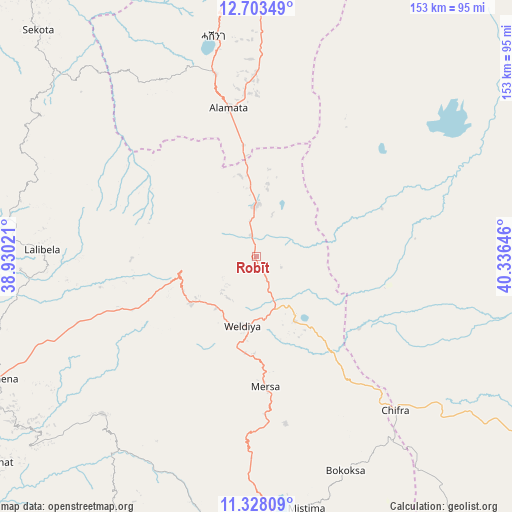
Robīt GPS coordinates[2]
12° 1' 0.012" North, 39° 37' 59.988" East
| Map corner | latitude | longitude |
|---|---|---|
| Upper-left | 12.70349°, | 38.93021° |
| Center: | 12.01667°, | 39.63333° |
| Lower-right: | 11.32809°, | 40.33646° |
| Map W x H: | 152.9×152.9 km | = 95×95mi |
| max Lat: | 14.277° ⇑10.3% North |
| Robīt: | 12.01667° |
| min Lat: | ⇓89.7% South 4.05° |
| min Long | Robīt | max Long |
| 34.53333° | 39.63333° | 42.8° |
| W 79.4%⇐ | ⇒20.6% E |
Elevation
Elevation of Robīt is 1597 m = 5240 ft, and this is 298.6 m = 980 ft below average elevation for this country.
| Max E: |
2854 m = 9364 ft | 78.5% |
| Avg. | 1895.6 m = 6219 ft | |
| Robīt | 1597 m = 5240 ft | |
Min E: |
367 m = 1204 ft | 21.5% |
See also: Ethiopia elevation on elevation.city.
Geographical zone
Robīt is located in North Torrid zone (between Equator and Tropic of Cancer). Distance of this Northern Tropic circle is 1269.8 km =789 mi to North.| Distance of | km | miles | from Robīt |
|---|---|---|---|
| North Pole | 8670.9 | 5387.8 | to North |
| Arctic Circle | 6065 | 3768.6 | to North |
| Tropic Cancer | 1269.8 | 789 | to North |
| Equator | 1336.1 | 830.2 | to South |


Nearby cities:
15 places around Robīt: (largest is in red/bold)
• Asaita
202.7 km =126 mi,  104°
104°
• Batī
100.8 km =62.6 mi,  155°
155°
• Debre Tabor
176.8 km =109.9 mi,  263°
263°
• Desē
98.2 km =61 mi,  180°
180°
• Dubti
160.8 km =99.9 mi, 101°
• Kemisē
146.8 km =91.2 mi,  169°
169°
• Kombolcha
104.7 km =65.1 mi, 173°
• Korem
55.7 km =34.6 mi,  347°
347°
• Lalībela
63.7 km =39.6 mi,  271°
271°
• Maych’ew
86.3 km =53.6 mi, 353°
• Mek'ele
165.5 km =102.8 mi, 354°
• Semera
151.4 km =94.1 mi, 99°
• Were Īlu
160.1 km =99.5 mi,  187°
187°
• Werota
210.6 km =130.9 mi, 266°
• Ādīs Zemen
201.5 km =125.2 mi, 273°
Sources, notices
• [Note1] Compared only with cities in Ethiopia existing in our database
• [Src1] Map data: © OpenStreetMap contributors (CC-BY-SA)
• [Src2] Other city data from geonames.org with taken over terms of usage.
• [Src3] Geographical zone / Annual Mean Temperature by Robert A. Rohde @ Wikipedia
