Kombolcha geodata
Kombolcha (Amhara) is a populated place; located in Ethiopia in Africa/Addis_Ababa (GMT+3) time zone. With population of 93,605 people, there are 10 cities with bigger population in this country. Compared to other cities in Ethiopia, 80.4% of cities are located further ↓South; 81.3% of cities are located further ←West and 54.2% of cities have higher elevation than Kombolcha. Note1


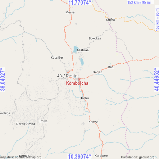
Kombolcha GPS coordinates[2]
11° 4' 53.58" North, 39° 44' 36.204" East
| Map corner | latitude | longitude |
|---|---|---|
| Upper-left | 11.77074°, | 39.04027° |
| Center: | 11.08155°, | 39.74339° |
| Lower-right: | 10.39074°, | 40.44652° |
| Map W x H: | 153.4×153.4 km | = 95.3×95.3mi |
| max Lat: | 14.277° ⇑19.6% North |
| Kombolcha: | 11.08155° |
| min Lat: | ⇓80.4% South 4.05° |
| min Long | Kombolcha | max Long |
| 34.53333° | 39.74339° | 42.8° |
| W 81.3%⇐ | ⇒18.7% E |
Elevation
Elevation of Kombolcha is 1883 m = 6178 ft, and this is 12.6 m = 41 ft below average elevation for this country.
| Max E: |
2854 m = 9364 ft | 54.2% |
| Avg. | 1895.6 m = 6219 ft | |
| Kombolcha | 1883 m = 6178 ft | |
Min E: |
367 m = 1204 ft | 45.8% |
See also: Kombolcha elevation on elevation.city.
Geographical zone
Kombolcha is located in North Torrid zone (between Equator and Tropic of Cancer). Distance of Equator is 1232.2 km =765.7 mi to South.| Distance of | km | miles | from Kombolcha |
|---|---|---|---|
| North Pole | 8774.9 | 5452.5 | to North |
| Arctic Circle | 6169 | 3833.2 | to North |
| Tropic Cancer | 1373.8 | 853.6 | to North |
| Equator | 1232.2 | 765.7 | to South |


Nearby cities:
15 places around Kombolcha: (largest is in red/bold)
• Abomsa
124.9 km =77.6 mi,  167°
167°
• Batī
32.2 km =20 mi,  67°
67°
• Debre Birhan
157.6 km =97.9 mi,  188°
188°
• Debre Sīna
137.2 km =85.3 mi,  179°
179°
• Debre Werk’
178.2 km =110.7 mi,  255°
255°
• Desē
13.3 km =8.3 mi,  295°
295°
• Dubti
162.9 km =101.2 mi,  63°
63°
• Fichē
180.3 km =112 mi,  217°
217°
• Gewanē
141.8 km =88.1 mi,  135°
135°
• Kemisē
42.9 km =26.7 mi,  161°
161°
• Korem
160.2 km =99.5 mi,  351°
351°
• Lalībela
130.1 km =80.8 mi,  324°
324°
• Robīt
104.7 km =65.1 mi, 353°
• Semera
158.7 km =98.6 mi, 60°
• Were Īlu
64.1 km =39.8 mi,  211°
211°
Sources, notices
• [Note1] Compared only with cities in Ethiopia existing in our database
• [Src1] Map data: © OpenStreetMap contributors (CC-BY-SA)
• [Src2] Other city data from geonames.org with taken over terms of usage.
• [Src3] Geographical zone / Annual Mean Temperature by Robert A. Rohde @ Wikipedia
