Maych’ew geodata
Maych’ew (Tigray) is a populated place; located in Ethiopia in Africa/Addis_Ababa (GMT+3) time zone. With population of 27,186 people, there are 44 cities with bigger population in this country. Compared to other cities in Ethiopia, 94.4% of cities are located further ↓South; 78.5% of cities are located further ←West and 76.6% of cities have lower elevation than Maych’ew. Note1


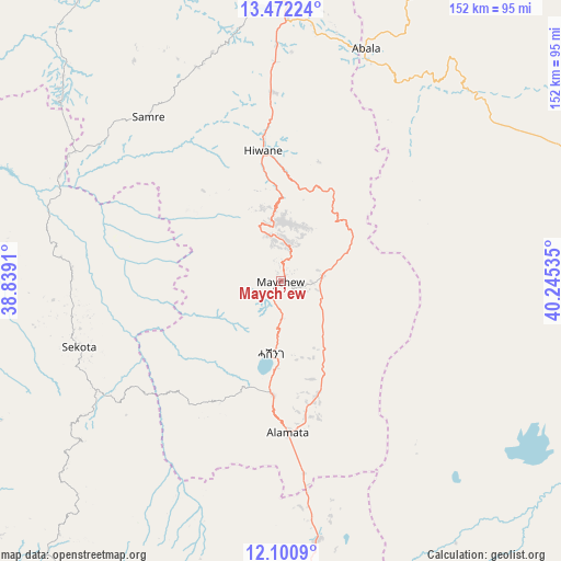
Maych’ew GPS coordinates[2]
12° 47' 15" North, 39° 32' 31.992" East
| Map corner | latitude | longitude |
|---|---|---|
| Upper-left | 13.47224°, | 38.8391° |
| Center: | 12.7875°, | 39.54222° |
| Lower-right: | 12.1009°, | 40.24535° |
| Map W x H: | 152.5×152.5 km | = 94.8×94.8mi |
| max Lat: | 14.277° ⇑5.6% North |
| Maych’ew: | 12.7875° |
| min Lat: | ⇓94.4% South 4.05° |
| min Long | Maych’ew | max Long |
| 34.53333° | 39.54222° | 42.8° |
| W 78.5%⇐ | ⇒21.5% E |
Elevation
Elevation of Maych’ew is 2400 m = 7874 ft, and this is 504.4 m = 1655 ft above average elevation for this country.
| Max E: |
2854 m = 9364 ft | 23.4% |
| Maych’ew | 2400 m 7874 ft | |
| Avg. | 1895.6 m = 6219 ft | |
Min E: |
367 m = 1204 ft | 76.6% |
See also: Ethiopia elevation on elevation.city.
Geographical zone
Maych’ew is located in North Torrid zone (between Equator and Tropic of Cancer). Distance of this Northern Tropic circle is 1184.1 km =735.8 mi to North.| Distance of | km | miles | from Maych’ew |
|---|---|---|---|
| North Pole | 8585.2 | 5334.6 | to North |
| Arctic Circle | 5979.3 | 3715.4 | to North |
| Tropic Cancer | 1184.1 | 735.8 | to North |
| Equator | 1421.8 | 883.5 | to South |


Nearby cities:
15 places around Maych’ew: (largest is in red/bold)
• Axum
172.7 km =107.3 mi,  329°
329°
• Batī
184.8 km =114.8 mi,  163°
163°
• Dabat
193.9 km =120.5 mi,  276°
276°
• Debark’
182.8 km =113.6 mi, 282°
• Debre Tabor
195.8 km =121.7 mi,  237°
237°
• Desē
184.2 km =114.5 mi,  176°
176°
• Dubti
204.3 km =126.9 mi,  125°
125°
• Inda Silasē
199.9 km =124.2 mi,  317°
317°
• Kombolcha
190.9 km =118.6 mi,  173°
173°
• Korem
31.4 km =19.5 mi, 183°
• Lalībela
99.7 km =62 mi,  212°
212°
• Mek'ele
79.2 km =49.2 mi,  354°
354°
• Robīt
86.3 km =53.6 mi, 173°
• Semera
193.6 km =120.3 mi,  124°
124°
• Ādīgrat
165.8 km =103 mi,  357°
357°
Sources, notices
• [Note1] Compared only with cities in Ethiopia existing in our database
• [Src1] Map data: © OpenStreetMap contributors (CC-BY-SA)
• [Src2] Other city data from geonames.org with taken over terms of usage.
• [Src3] Geographical zone / Annual Mean Temperature by Robert A. Rohde @ Wikipedia
