Axum geodata
Axum (Tigray) is a populated place; located in Ethiopia in Africa/Addis_Ababa (GMT+3) time zone. With population of 41,249 people, there are 25 cities with bigger population in this country. Compared to other cities in Ethiopia, 99.1% of cities are located further ↓South; 58.9% of cities are located further ←West and 68.2% of cities have lower elevation than Axum. Note1


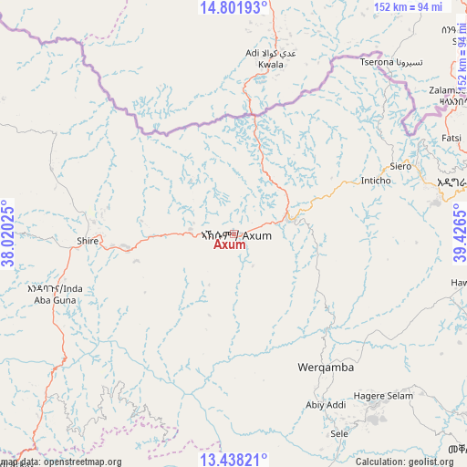
Axum GPS coordinates[2]
14° 7' 15.924" North, 38° 43' 24.132" East
| Map corner | latitude | longitude |
|---|---|---|
| Upper-left | 14.80193°, | 38.02025° |
| Center: | 14.12109°, | 38.72337° |
| Lower-right: | 13.43821°, | 39.4265° |
| Map W x H: | 151.6×151.6 km | = 94.2×94.2mi |
| max Lat: | 14.277° ⇑0.9% North |
| Axum: | 14.12109° |
| min Lat: | ⇓99.1% South 4.05° |
| min Long | Axum | max Long |
| 34.53333° | 38.72337° | 42.8° |
| W 58.9%⇐ | ⇒41.1% E |
Elevation
Elevation of Axum is 2131 m = 6991 ft, and this is 235.4 m = 772 ft above average elevation for this country.
| Max E: |
2854 m = 9364 ft | 31.8% |
| Axum | 2131 m 6991 ft | |
| Avg. | 1895.6 m = 6219 ft | |
Min E: |
367 m = 1204 ft | 68.2% |
See also: Axum elevation on elevation.city.
Geographical zone
Axum is located in North Torrid zone (between Equator and Tropic of Cancer). Distance of this Northern Tropic circle is 1035.8 km =643.6 mi to North.| Distance of | km | miles | from Axum |
|---|---|---|---|
| North Pole | 8436.9 | 5242.4 | to North |
| Arctic Circle | 5831.1 | 3623.3 | to North |
| Tropic Cancer | 1035.8 | 643.6 | to North |
| Equator | 1570.1 | 975.6 | to South |


Nearby cities:
15 places around Axum: (largest is in red/bold)
• Addiet Canna
344.7 km =214.2 mi,  202°
202°
• Bahir Dar
316 km =196.4 mi,  207°
207°
• Dabat
163.4 km =101.5 mi,  219°
219°
• Debark’
139.5 km =86.7 mi, 219°
• Debre Tabor
263.9 km =164 mi, 196°
• Gondar
217 km =134.8 mi, 218°
• Inda Silasē
47.5 km =29.5 mi,  267°
267°
• Korem
199.3 km =123.8 mi,  154°
154°
• Lalībela
234.9 km =146 mi,  171°
171°
• Maych’ew
172.7 km =107.3 mi, 149°
• Mek'ele
106.8 km =66.4 mi,  130°
130°
• Robīt
253.9 km =157.8 mi,  157°
157°
• Werota
269 km =167.1 mi, 204°
• Ādīgrat
81.5 km =50.6 mi,  77°
77°
• Ādīs Zemen
245 km =152.2 mi, 204°
Sources, notices
• [Note1] Compared only with cities in Ethiopia existing in our database
• [Src1] Map data: © OpenStreetMap contributors (CC-BY-SA)
• [Src2] Other city data from geonames.org with taken over terms of usage.
• [Src3] Geographical zone / Annual Mean Temperature by Robert A. Rohde @ Wikipedia
