Āsbe Teferī geodata
Āsbe Teferī (Oromiya) is a populated place; located in Ethiopia in Africa/Addis_Ababa (GMT+3) time zone. With population of 30,772 people, there are 37 cities with bigger population in this country. Compared to other cities in Ethiopia, 56.1% of cities are located further ↓South; 92.5% of cities are located further ←West and 65.4% of cities have higher elevation than Āsbe Teferī. Note1


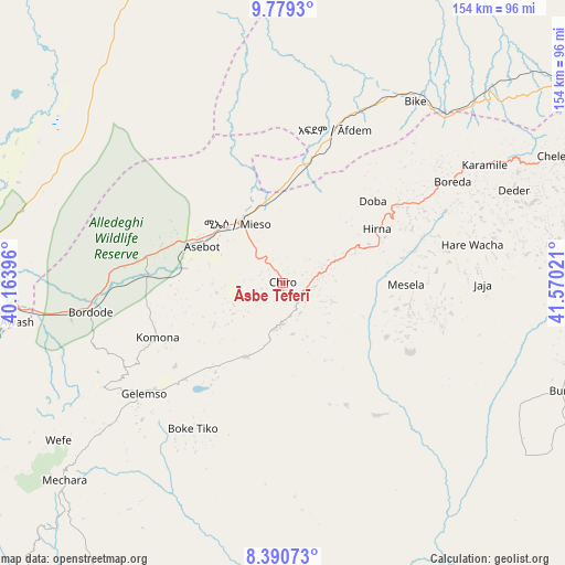
Āsbe Teferī GPS coordinates[2]
9° 5' 8.484" North, 40° 52' 1.488" East
| Map corner | latitude | longitude |
|---|---|---|
| Upper-left | 9.7793°, | 40.16396° |
| Center: | 9.08569°, | 40.86708° |
| Lower-right: | 8.39073°, | 41.57021° |
| Map W x H: | 154.4×154.4 km | = 95.9×95.9mi |
| max Lat: | 14.277° ⇑43.9% North |
| Āsbe Teferī: | 9.08569° |
| min Lat: | ⇓56.1% South 4.05° |
| min Long | Āsbe Teferī | max Long |
| 34.53333° | 40.86708° | 42.8° |
| W 92.5%⇐ | ⇒7.5% E |
Elevation
Elevation of Āsbe Teferī is 1750 m = 5741 ft, and this is 145.6 m = 478 ft below average elevation for this country.
| Max E: |
2854 m = 9364 ft | 65.4% |
| Avg. | 1895.6 m = 6219 ft | |
| Āsbe Teferī | 1750 m = 5741 ft | |
Min E: |
367 m = 1204 ft | 34.6% |
See also: Ethiopia elevation on elevation.city.
Geographical zone
Āsbe Teferī is located in North Torrid zone (between Equator and Tropic of Cancer). Distance of Equator is 1010.2 km =627.7 mi to South.| Distance of | km | miles | from Āsbe Teferī |
|---|---|---|---|
| North Pole | 8996.8 | 5590.4 | to North |
| Arctic Circle | 6390.9 | 3971.1 | to North |
| Tropic Cancer | 1595.7 | 991.5 | to North |
| Equator | 1010.2 | 627.7 | to South |


Nearby cities:
15 places around Āsbe Teferī: (largest is in red/bold)
• Abomsa
139.1 km =86.4 mi,  315°
315°
• Bedēsa
22.6 km =14 mi,  204°
204°
• Debre Birhan
160.6 km =99.8 mi,  294°
294°
• Debre Sīna
148 km =92 mi,  304°
304°
• Deder
68 km =42.3 mi,  68°
68°
• Dire Dawa
123.3 km =76.6 mi,  62°
62°
• Gelemso
48.7 km =30.3 mi,  232°
232°
• Gewanē
122.6 km =76.2 mi,  348°
348°
• Harar
139.6 km =86.7 mi,  79°
79°
• Hīrna
29.4 km =18.3 mi, 60°
• Metahāra
106.4 km =66.1 mi,  258°
258°
• Nazrēt
185.7 km =115.4 mi,  251°
251°
• Sirre
174.5 km =108.4 mi,  240°
240°
• Wenjī
187.8 km =116.7 mi, 247°
• Āwash
77.7 km =48.3 mi, 261°
Sources, notices
• [Note1] Compared only with cities in Ethiopia existing in our database
• [Src1] Map data: © OpenStreetMap contributors (CC-BY-SA)
• [Src2] Other city data from geonames.org with taken over terms of usage.
• [Src3] Geographical zone / Annual Mean Temperature by Robert A. Rohde @ Wikipedia
