Arāk geodata
Arāk (Markazi) is a seat of a first-order administrative division; located in Iran in Asia/Tehran (GMT+3.5) time zone. With population of 503,647 people, there are 17 cities with bigger population in this country. Compared to other cities in Iran, 52.2% of cities are located further ↑North; 64.6% of cities are located further →East and 83% of cities have lower elevation than Arāk. Note1


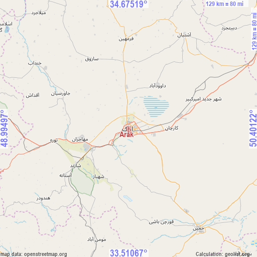
Arāk GPS coordinates[2]
34° 5' 41.748" North, 49° 41' 53.124" East
| Map corner | latitude | longitude |
|---|---|---|
| Upper-left | 34.67519°, | 48.99497° |
| Center: | 34.09493°, | 49.69809° |
| Lower-right: | 33.51067°, | 50.40122° |
| Map W x H: | 129.5×129.5 km | = 80.5×80.5mi |
| max Lat: | 39.6482° ⇑52.2% North |
| Arāk: | 34.09493° |
| min Lat: | ⇓47.8% South 25.2919° |
| min Long | Arāk | max Long |
| 44.38416° | 49.69809° | 61.9965° |
| W 35.4%⇐ | ⇒64.6% E |
Elevation
Elevation of Arāk is 1728 m = 5669 ft, and this is 679 m = 2228 ft above average elevation for this country.
| Max E: |
2564 m = 8412 ft | 17% |
| Arāk | 1728 m 5669 ft | |
| Avg. | 1049 m = 3442 ft | |
Min E: |
-24 m = -79 ft | 83% |
See also: Arāk elevation on elevation.city.
Geographical zone
Arāk is located in North temperate zone (between Tropic of Cancer and the Arctic Circle). Distance of this Northern Tropic circle is 1185.1 km =736.4 mi to South.| Distance of | km | miles | from Arāk |
|---|---|---|---|
| North Pole | 6216.1 | 3862.5 | to North |
| Arctic Circle | 3610.2 | 2243.3 | to North |
| Tropic Cancer | 1185.1 | 736.4 | to South |
| Equator | 3791 | 2355.6 | to South |


Nearby cities:
15 places around Arāk: (largest is in red/bold)
• Alīgūdarz
76.8 km =47.7 mi,  180°
180°
• Aznā
74.4 km =46.2 mi,  197°
197°
• Aznā
89.1 km =55.4 mi,  232°
232°
• Borūjerd
90 km =55.9 mi,  255°
255°
• Dorūd
89.2 km =55.4 mi,  221°
221°
• Farmahīn
45.5 km =28.3 mi,  358°
358°
• Golpāyegān
89.8 km =55.8 mi,  142°
142°
• Khomeyn
61.8 km =38.4 mi,  145°
145°
• Khondāb
57.7 km =35.9 mi,  305°
305°
• Komījān
77.6 km =48.2 mi,  333°
333°
• Malāyer
83.8 km =52.1 mi,  285°
285°
• Maḩallāt
72.5 km =45 mi,  106°
106°
• Shāzand
32.5 km =20.2 mi,  235°
235°
• Tafresh
72.6 km =45.1 mi,  23°
23°
• Āshtīān
55.4 km =34.4 mi,  30°
30°
Sources, notices
• [Note1] Compared only with cities in Iran existing in our database
• [Src1] Map data: © OpenStreetMap contributors (CC-BY-SA)
• [Src2] Other city data from geonames.org with taken over terms of usage.
• [Src3] Geographical zone / Annual Mean Temperature by Robert A. Rohde @ Wikipedia
