Farmahīn geodata
Farmahīn (Markazi) is a seat of a second-order administrative division; located in Iran in Asia/Tehran (GMT+3.5) time zone. In our database, there are 232 cities with bigger population. Compared to other cities in Iran, 51% of cities are located further ↓South; 65.3% of cities are located further →East and 84.6% of cities have lower elevation than Farmahīn. Note1


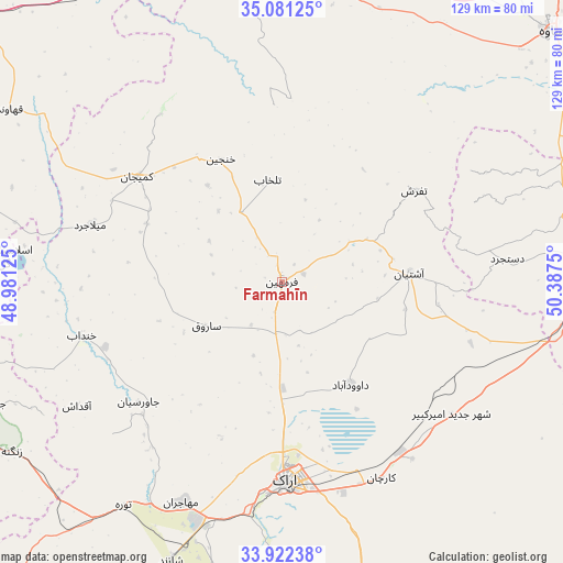
Farmahīn GPS coordinates[2]
34° 30' 13.788" North, 49° 41' 3.732" East
| Map corner | latitude | longitude |
|---|---|---|
| Upper-left | 35.08125°, | 48.98125° |
| Center: | 34.50383°, | 49.68437° |
| Lower-right: | 33.92238°, | 50.3875° |
| Map W x H: | 128.9×128.9 km | = 80.1×80.1mi |
| max Lat: | 39.6482° ⇑49% North |
| Farmahīn: | 34.50383° |
| min Lat: | ⇓51% South 25.2919° |
| min Long | Farmahīn | max Long |
| 44.38416° | 49.68437° | 61.9965° |
| W 34.7%⇐ | ⇒65.3% E |
Elevation
Elevation of Farmahīn is 1782 m = 5846 ft, and this is 733 m = 2405 ft above average elevation for this country.
| Max E: |
2564 m = 8412 ft | 15.4% |
| Farmahīn | 1782 m 5846 ft | |
| Avg. | 1049 m = 3442 ft | |
Min E: |
-24 m = -79 ft | 84.6% |
See also: Iran elevation on elevation.city.
Geographical zone
Farmahīn is located in North temperate zone (between Tropic of Cancer and the Arctic Circle). Distance of this Northern Tropic circle is 1230.5 km =764.6 mi to South.| Distance of | km | miles | from Farmahīn |
|---|---|---|---|
| North Pole | 6170.6 | 3834.2 | to North |
| Arctic Circle | 3564.7 | 2215 | to North |
| Tropic Cancer | 1230.5 | 764.6 | to South |
| Equator | 3836.5 | 2383.9 | to South |


Nearby cities:
15 places around Farmahīn: (largest is in red/bold)
• Arāk
45.5 km =28.3 mi,  178°
178°
• Borūjerd
109.1 km =67.8 mi,  231°
231°
• Delījān
108.1 km =67.2 mi,  121°
121°
• Fāmenīn
94 km =58.4 mi,  316°
316°
• Khomeyn
102.8 km =63.9 mi,  159°
159°
• Khondāb
47.5 km =29.5 mi,  254°
254°
• Komījān
40.7 km =25.3 mi,  306°
306°
• Malāyer
82.3 km =51.1 mi, 254°
• Maḩallāt
96.7 km =60.1 mi,  132°
132°
• Qom
110.2 km =68.5 mi,  82°
82°
• Shāzand
68.6 km =42.6 mi,  201°
201°
• Sāveh
84.1 km =52.3 mi,  46°
46°
• Tafresh
36.9 km =22.9 mi,  55°
55°
• Āshtīān
29.6 km =18.4 mi,  85°
85°
• Āzādshahr
106.8 km =66.4 mi,  287°
287°
Sources, notices
• [Note1] Compared only with cities in Iran existing in our database
• [Src1] Map data: © OpenStreetMap contributors (CC-BY-SA)
• [Src2] Other city data from geonames.org with taken over terms of usage.
• [Src3] Geographical zone / Annual Mean Temperature by Robert A. Rohde @ Wikipedia
