Komījān geodata
Komījān (Markazi) is a seat of a second-order administrative division; located in Iran in Asia/Tehran (GMT+3.5) time zone. In our database, there are 232 cities with bigger population. Compared to other cities in Iran, 53.3% of cities are located further ↓South; 68% of cities are located further →East and 84.6% of cities have lower elevation than Komījān. Note1


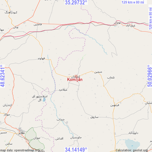
Komījān GPS coordinates[2]
34° 43' 17.112" North, 49° 19' 35.508" East
| Map corner | latitude | longitude |
|---|---|---|
| Upper-left | 35.29732°, | 48.62341° |
| Center: | 34.72142°, | 49.32653° |
| Lower-right: | 34.14149°, | 50.02966° |
| Map W x H: | 128.5×128.5 km | = 79.8×79.8mi |
| max Lat: | 39.6482° ⇑46.7% North |
| Komījān: | 34.72142° |
| min Lat: | ⇓53.3% South 25.2919° |
| min Long | Komījān | max Long |
| 44.38416° | 49.32653° | 61.9965° |
| W 32%⇐ | ⇒68% E |
Elevation
Elevation of Komījān is 1782 m = 5846 ft, and this is 733 m = 2405 ft above average elevation for this country.
| Max E: |
2564 m = 8412 ft | 15.4% |
| Komījān | 1782 m 5846 ft | |
| Avg. | 1049 m = 3442 ft | |
Min E: |
-24 m = -79 ft | 84.6% |
See also: Iran elevation on elevation.city.
Geographical zone
Komījān is located in North temperate zone (between Tropic of Cancer and the Arctic Circle). Distance of this Northern Tropic circle is 1254.7 km =779.6 mi to South.| Distance of | km | miles | from Komījān |
|---|---|---|---|
| North Pole | 6146.4 | 3819.2 | to North |
| Arctic Circle | 3540.5 | 2200 | to North |
| Tropic Cancer | 1254.7 | 779.6 | to South |
| Equator | 3860.7 | 2398.9 | to South |


Nearby cities:
15 places around Komījān: (largest is in red/bold)
• Arāk
77.6 km =48.2 mi,  153°
153°
• Bahār
83.4 km =51.8 mi,  284°
284°
• Farmahīn
40.7 km =25.3 mi,  126°
126°
• Fāmenīn
54.4 km =33.8 mi,  323°
323°
• Hamadān
74.7 km =46.4 mi, 276°
• Kabūdarāhang
77.2 km =48 mi,  314°
314°
• Khondāb
38.8 km =24.1 mi,  199°
199°
• Malāyer
65.7 km =40.8 mi,  224°
224°
• Pasragad Branch
78.3 km =48.7 mi,  274°
274°
• Razan
78.6 km =48.8 mi,  340°
340°
• Shāzand
88.2 km =54.8 mi,  175°
175°
• Tafresh
63.1 km =39.2 mi,  92°
92°
• Tūyserkān
83 km =51.6 mi,  256°
256°
• Āshtīān
66 km =41 mi,  109°
109°
• Āzādshahr
69.5 km =43.2 mi, 276°
Sources, notices
• [Note1] Compared only with cities in Iran existing in our database
• [Src1] Map data: © OpenStreetMap contributors (CC-BY-SA)
• [Src2] Other city data from geonames.org with taken over terms of usage.
• [Src3] Geographical zone / Annual Mean Temperature by Robert A. Rohde @ Wikipedia
