Khāsh geodata
Khāsh (Sistan and Baluchestan) is a seat of a second-order administrative division; located in Iran in Asia/Tehran (GMT+3.5) time zone. With population of 69,603 people, there are 97 cities with bigger population in this country. Compared to other cities in Iran, 92.1% of cities are located further ↑North; 98.6% of cities are located further ←West and 65.8% of cities have lower elevation than Khāsh. Note1


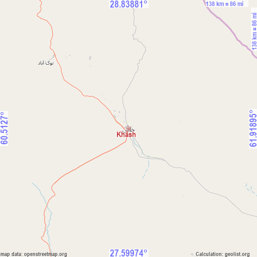
Khāsh GPS coordinates[2]
28° 13' 15.852" North, 61° 12' 56.952" East
| Map corner | latitude | longitude |
|---|---|---|
| Upper-left | 28.83881°, | 60.5127° |
| Center: | 28.22107°, | 61.21582° |
| Lower-right: | 27.59974°, | 61.91895° |
| Map W x H: | 137.8×137.8 km | = 85.6×85.6mi |
| max Lat: | 39.6482° ⇑92.1% North |
| Khāsh: | 28.22107° |
| min Lat: | ⇓7.9% South 25.2919° |
| min Long | Khāsh | max Long |
| 44.38416° | 61.21582° | 61.9965° |
| W 98.6%⇐ | ⇒1.4% E |
Elevation
Elevation of Khāsh is 1413 m = 4636 ft, and this is 364 m = 1194 ft above average elevation for this country.
| Max E: |
2564 m = 8412 ft | 34.2% |
| Khāsh | 1413 m 4636 ft | |
| Avg. | 1049 m = 3442 ft | |
Min E: |
-24 m = -79 ft | 65.8% |
See also: Khāsh elevation on elevation.city.
Geographical zone
Khāsh is located in North temperate zone (between Tropic of Cancer and the Arctic Circle). Distance of this Northern Tropic circle is 532 km =330.6 mi to South.| Distance of | km | miles | from Khāsh |
|---|---|---|---|
| North Pole | 6869.2 | 4268.3 | to North |
| Arctic Circle | 4263.3 | 2649.1 | to North |
| Tropic Cancer | 532 | 330.6 | to South |
| Equator | 3137.9 | 1949.8 | to South |


Nearby cities:
15 places around Khāsh: (largest is in red/bold)
• Bam
295.8 km =183.8 mi,  289°
289°
• Dalgān
192.4 km =119.6 mi,  244°
244°
• Fahraj
241.6 km =150.1 mi, 289°
• Fannūj
240.1 km =149.2 mi,  220°
220°
• Iranshahr
124.7 km =77.5 mi,  204°
204°
• Moḩammadābād
215.3 km =133.8 mi,  283°
283°
• Narmāshīr
258.9 km =160.9 mi, 288°
• Noşratābād
221.8 km =137.8 mi,  327°
327°
• Nīkshahr
242.9 km =150.9 mi, 204°
• Qaşr-e Qand
224.1 km =139.2 mi,  191°
191°
• Rāsak
221.4 km =137.6 mi,  175°
175°
• Sūrān
129.3 km =80.3 mi,  143°
143°
• Zahedan
145.9 km =90.7 mi,  346°
346°
• Zehak
300.6 km =186.8 mi,  8°
8°
• Zābolī
129.3 km =80.3 mi,  159°
159°
Sources, notices
• [Note1] Compared only with cities in Iran existing in our database
• [Src1] Map data: © OpenStreetMap contributors (CC-BY-SA)
• [Src2] Other city data from geonames.org with taken over terms of usage.
• [Src3] Geographical zone / Annual Mean Temperature by Robert A. Rohde @ Wikipedia
