Konārak geodata
Konārak (Sistan and Baluchestan) is a seat of a second-order administrative division; located in Iran in Asia/Tehran (GMT+3.5) time zone. In our database, there are 232 cities with bigger population. Compared to other cities in Iran, 99.8% of cities are located further ↑North; 96.8% of cities are located further ←West and 93.9% of cities have higher elevation than Konārak. Note1


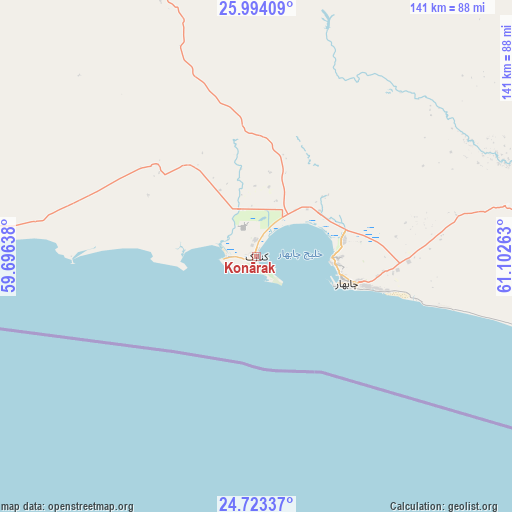
Konārak GPS coordinates[2]
25° 21' 37.44" North, 60° 23' 58.2" East
| Map corner | latitude | longitude |
|---|---|---|
| Upper-left | 25.99409°, | 59.69638° |
| Center: | 25.3604°, | 60.3995° |
| Lower-right: | 24.72337°, | 61.10263° |
| Map W x H: | 141.3×141.3 km | = 87.8×87.8mi |
| max Lat: | 39.6482° ⇑99.8% North |
| Konārak: | 25.3604° |
| min Lat: | ⇓0.2% South 25.2919° |
| min Long | Konārak | max Long |
| 44.38416° | 60.3995° | 61.9965° |
| W 96.8%⇐ | ⇒3.2% E |
Elevation
Elevation of Konārak is 6 m = 20 ft, and this is 1043 m = 3422 ft below average elevation for this country.
| Max E: |
2564 m = 8412 ft | 93.9% |
| Avg. | 1049 m = 3442 ft | |
| Konārak | 6 m = 20 ft | |
Min E: |
-24 m = -79 ft | 6.1% |
See also: Iran elevation on elevation.city.
Geographical zone
Konārak is located in North temperate zone (between Tropic of Cancer and the Arctic Circle). Distance of this Northern Tropic circle is 213.9 km =132.9 mi to South.| Distance of | km | miles | from Konārak |
|---|---|---|---|
| North Pole | 7187.2 | 4465.9 | to North |
| Arctic Circle | 4581.4 | 2846.7 | to North |
| Tropic Cancer | 213.9 | 132.9 | to South |
| Equator | 2819.8 | 1752.1 | to South |


Nearby cities:
15 places around Konārak: (largest is in red/bold)
• Chabahar
25.6 km =15.9 mi,  107°
107°
• Dalgān
254.3 km =158 mi,  338°
338°
• Eslāmābād
380.3 km =236.3 mi,  321°
321°
• Fannūj
155 km =96.3 mi,  330°
330°
• Iranshahr
206.8 km =128.5 mi,  7°
7°
• Jask
265.2 km =164.8 mi,  276°
276°
• Khāsh
328.2 km =203.9 mi, 14°
• Manūjān
367.6 km =228.4 mi,  308°
308°
• Nīkshahr
98 km =60.9 mi,  349°
349°
• Qal‘eh Ganj
347.4 km =215.9 mi, 313°
• Qaşr-e Qand
104.9 km =65.2 mi,  19°
19°
• Rāsak
139.7 km =86.8 mi,  45°
45°
• Sardasht
277.8 km =172.6 mi,  296°
296°
• Sūrān
266.7 km =165.7 mi,  36°
36°
• Zābolī
234.4 km =145.6 mi,  32°
32°
Sources, notices
• [Note1] Compared only with cities in Iran existing in our database
• [Src1] Map data: © OpenStreetMap contributors (CC-BY-SA)
• [Src2] Other city data from geonames.org with taken over terms of usage.
• [Src3] Geographical zone / Annual Mean Temperature by Robert A. Rohde @ Wikipedia
