Dūst Moḩammad Khān geodata
Dūst Moḩammad Khān (Sistan and Baluchestan) is a seat of a second-order administrative division; located in Iran in Asia/Tehran (GMT+3.5) time zone. In our database, there are 232 cities with bigger population. Compared to other cities in Iran, 75.3% of cities are located further ↑North; 99.8% of cities are located further ←West and 73.9% of cities have higher elevation than Dūst Moḩammad Khān. Note1


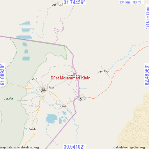
Dūst Moḩammad Khān GPS coordinates[2]
31° 8' 40.92" North, 61° 47' 33" East
| Map corner | latitude | longitude |
|---|---|---|
| Upper-left | 31.74456°, | 61.08938° |
| Center: | 31.1447°, | 61.7925° |
| Lower-right: | 30.54102°, | 62.49563° |
| Map W x H: | 133.8×133.8 km | = 83.1×83.1mi |
| max Lat: | 39.6482° ⇑75.3% North |
| Dūst Moḩammad Khān: | 31.1447° |
| min Lat: | ⇓24.7% South 25.2919° |
| min Long | Dūst Moḩamma | max Long |
| 44.38416° | 61.7925° | 61.9965° |
| W 99.8%⇐ | ⇒0.2% E |
Elevation
Elevation of Dūst Moḩammad Khān is 483 m = 1585 ft, and this is 566 m = 1857 ft below average elevation for this country.
| Max E: |
2564 m = 8412 ft | 73.9% |
| Avg. | 1049 m = 3442 ft | |
| Dūst Moḩammad Khān | 483 m = 1585 ft | |
Min E: |
-24 m = -79 ft | 26.1% |
See also: Iran elevation on elevation.city.
Geographical zone
Dūst Moḩammad Khān is located in North temperate zone (between Tropic of Cancer and the Arctic Circle). Distance of this Northern Tropic circle is 857 km =532.5 mi to South.| Distance of | km | miles | from Dūst Moḩammad Khān |
|---|---|---|---|
| North Pole | 6544.1 | 4066.3 | to North |
| Arctic Circle | 3938.2 | 2447.1 | to North |
| Tropic Cancer | 857 | 532.5 | to South |
| Equator | 3463 | 2151.8 | to South |


Nearby cities:
15 places around Dūst Moḩammad Khān: (largest is in red/bold)
• Asadīyeh
279.5 km =173.7 mi,  315°
315°
• Bam
400.6 km =248.9 mi,  235°
235°
• Bīrjand
308.9 km =191.9 mi,  308°
308°
• Fahraj
371.2 km =230.7 mi,  228°
228°
• Khāsh
329.8 km =204.9 mi,  189°
189°
• Moḩammadābād
380.1 km =236.2 mi,  223°
223°
• Narmāshīr
384.9 km =239.2 mi, 230°
• Nehbandān
172.5 km =107.2 mi,  284°
284°
• Noşratābād
221.8 km =137.8 mi, 231°
• Qā’en
377.2 km =234.4 mi, 319°
• Sarbīsheh
246.5 km =153.2 mi, 310°
• Zahedan
203.8 km =126.6 mi,  205°
205°
• Zehak
29.9 km =18.6 mi,  200°
200°
• Zābol
31 km =19.3 mi,  245°
245°
• Ḩājjīābād
321.5 km =199.8 mi,  328°
328°
Sources, notices
• [Note1] Compared only with cities in Iran existing in our database
• [Src1] Map data: © OpenStreetMap contributors (CC-BY-SA)
• [Src2] Other city data from geonames.org with taken over terms of usage.
• [Src3] Geographical zone / Annual Mean Temperature by Robert A. Rohde @ Wikipedia
