Lodwar geodata
Lodwar (Turkana) is a seat of a first-order administrative division; located in Kenya in Africa/Nairobi (GMT+3) time zone. With population of 20,219 people, there are 46 cities with bigger population in this country. Compared to other cities in Kenya, 98.2% of cities are located further ↓South; 62.3% of cities are located further →East and 85.1% of cities have higher elevation than Lodwar. Note1


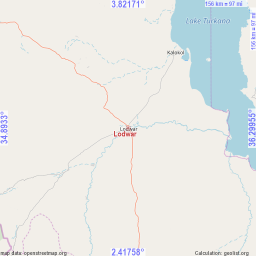
Lodwar GPS coordinates[2]
3° 7' 11.568" North, 35° 35' 47.112" East
| Map corner | latitude | longitude |
|---|---|---|
| Upper-left | 3.82171°, | 34.8933° |
| Center: | 3.11988°, | 35.59642° |
| Lower-right: | 2.41758°, | 36.29955° |
| Map W x H: | 156.1×156.1 km | = 97×97mi |
| max Lat: | 3.93726° ⇑1.8% North |
| Lodwar: | 3.11988° |
| min Lat: | ⇓98.2% South -4.64756° |
| min Long | Lodwar | max Long |
| 33.97248° | 35.59642° | 41.85688° |
| W 37.7%⇐ | ⇒62.3% E |
Elevation
Elevation of Lodwar is 500 m = 1640 ft, and this is 846.7 m = 2778 ft below average elevation for this country.
| Max E: |
2514 m = 8248 ft | 85.1% |
| Avg. | 1346.7 m = 4418 ft | |
| Lodwar | 500 m = 1640 ft | |
Min E: |
7 m = 23 ft | 14.9% |
See also: Kenya elevation on elevation.city.
Geographical zone
Lodwar is located in North Torrid zone (between Equator and Tropic of Cancer). Distance of Equator is 346.9 km =215.6 mi to South.| Distance of | km | miles | from Lodwar |
|---|---|---|---|
| North Pole | 9660.2 | 6002.6 | to North |
| Arctic Circle | 7054.3 | 4383.3 | to North |
| Tropic Cancer | 2259 | 1403.7 | to North |
| Equator | 346.9 | 215.6 | to South |


Nearby cities:
15 places around Lodwar: (largest is in red/bold)
• Baringo
297.9 km =185.1 mi,  172°
172°
• Bungoma
303.7 km =188.7 mi,  201°
201°
• Bungoma
306.7 km =190.6 mi, 202°
• Chepareria
206.4 km =128.3 mi,  192°
192°
• Eldoret
291.3 km =181 mi, 187°
• Iten
272.5 km =169.3 mi,  182°
182°
• Kabarnet
292.7 km =181.9 mi, 176°
• Kapenguria
216 km =134.2 mi, 194°
• Kapsowar
238.1 km =147.9 mi, 181°
• Kitale
243 km =151 mi, 195°
• Malaba
312.5 km =194.2 mi,  207°
207°
• Malikisi
301.4 km =187.3 mi, 205°
• Maralal
256.1 km =159.1 mi,  151°
151°
• Marsabit
279.9 km =173.9 mi,  108°
108°
• Webuye
294.8 km =183.2 mi, 198°
Sources, notices
• [Note1] Compared only with cities in Kenya existing in our database
• [Src1] Map data: © OpenStreetMap contributors (CC-BY-SA)
• [Src2] Other city data from geonames.org with taken over terms of usage.
• [Src3] Geographical zone / Annual Mean Temperature by Robert A. Rohde @ Wikipedia
